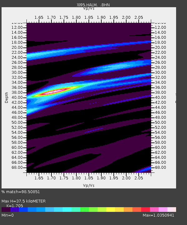
HALM XI.HALM - Earthquake Result Viewer

Earthquake location: Samar, Philippines
Earthquake latitude/longitude: 12.6/125.2
Earthquake time(UTC): 1996/06/11 (163) 18:22:55 GMT
Earthquake Depth: 33 km
Earthquake Magnitude: 6.0 MB, 7.0 MS, 7.2 UNKNOWN, 7.1 MW
Earthquake Catalog/Contributor: WHDF/NEIC
Network: XI Saudi Arabia Broadband Array
Station: HALM XI.HALM
Lat/Lon: 22.85 N/44.32 E
Elevation: 930 m
Distance: 76.9 deg
Az: 290.746 deg
Baz: 81.725 deg
Ray Param: 0.050658096
Estimated Moho Depth: 37.5 km
Estimated Crust Vp/Vs: 1.71
Assumed Crust Vp: 6.498 km/s
Estimated Crust Vs: 3.811 km/s
Estimated Crust Poisson's Ratio: 0.24
Radial Match: 98.50851 %
Radial Bump: 230
Transverse Match: 83.279594 %
Transverse Bump: 400
SOD ConfigId: 6273
Insert Time: 2010-03-09 23:36:39.693 +0000
GWidth: 2.5
Max Bumps: 400
Tol: 0.001

Signal To Noise

ChannelStoNSTALTA
XI:HALM: :BHN:19960611T18:34:13.405017Z0.83335511.4959964E-71.7951488E-7
XI:HALM: :BHE:19960611T18:34:13.405017Z4.9843274.645369E-79.3199525E-8
XI:HALM: :BHZ:19960611T18:34:13.405017Z9.82397651.1274097E-61.1476103E-7
Arrivals
Ps4.2 SECOND
PpPs15 SECOND
PsPs/PpSs19 SECOND