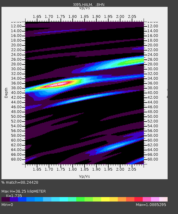
HALM XI.HALM - Earthquake Result Viewer

Earthquake location: Luzon, Philippines
Earthquake latitude/longitude: 14.5/120.0
Earthquake time(UTC): 1996/07/30 (212) 17:38:30 GMT
Earthquake Depth: 33 km
Earthquake Magnitude: 6.1 MB, 5.7 MS, 6.1 UNKNOWN, 5.9 MW
Earthquake Catalog/Contributor: WHDF/NEIC
Network: XI Saudi Arabia Broadband Array
Station: HALM XI.HALM
Lat/Lon: 22.85 N/44.32 E
Elevation: 930 m
Distance: 71.5 deg
Az: 289.526 deg
Baz: 81.698 deg
Ray Param: 0.054254774
Estimated Moho Depth: 36.25 km
Estimated Crust Vp/Vs: 1.74
Assumed Crust Vp: 6.498 km/s
Estimated Crust Vs: 3.745 km/s
Estimated Crust Poisson's Ratio: 0.25
Radial Match: 88.24428 %
Radial Bump: 400
Transverse Match: 43.97675 %
Transverse Bump: 400
SOD ConfigId: 6273
Insert Time: 2010-03-09 23:36:44.065 +0000
GWidth: 2.5
Max Bumps: 400
Tol: 0.001

Signal To Noise

ChannelStoNSTALTA
XI:HALM: :BHN:19960730T17:49:17.025012Z1.22638193.342663E-72.7256297E-7
XI:HALM: :BHE:19960730T17:49:17.025012Z1.9851994.0862963E-72.0583813E-7
XI:HALM: :BHZ:19960730T17:49:17.025012Z4.9826481.0442245E-62.095722E-7
Arrivals
Ps4.3 SECOND
PpPs15 SECOND
PsPs/PpSs19 SECOND