You are here: Home > Network List > XI95 - Saudi Arabia Broadband Array Stations List
> Station HALM XI.HALM > Earthquake Result Viewer
HALM XI.HALM - Earthquake Result Viewer
| Earthquake location: |
Southeast Of Honshu, Japan |
| Earthquake latitude/longitude: |
29.2/140.4 |
| Earthquake time(UTC): |
1996/02/14 (045) 21:26:56 GMT |
| Earthquake Depth: |
142 km |
| Earthquake Magnitude: |
5.9 MB |
| Earthquake Catalog/Contributor: |
WHDF/NEIC |
|
| Network: |
XI Saudi Arabia Broadband Array |
| Station: |
HALM XI.HALM |
| Lat/Lon: |
22.85 N/44.32 E |
| Elevation: |
930 m |
|
| Distance: |
84.1 deg |
| Az: |
292.757 deg |
| Baz: |
60.907 deg |
| Ray Param: |
0.04537694 |
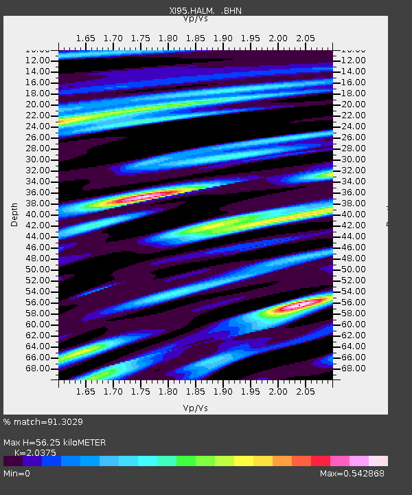
| Estimated Moho Depth: |
56.25 km |
| Estimated Crust Vp/Vs: |
2.04 |
| Assumed Crust Vp: |
6.498 km/s |
| Estimated Crust Vs: |
3.189 km/s |
| Estimated Crust Poisson's Ratio: |
0.34 |
|
| Radial Match: |
91.3029 % |
| Radial Bump: |
400 |
| Transverse Match: |
67.49858 % |
| Transverse Bump: |
400 |
| SOD ConfigId: |
4480 |
| Insert Time: |
2010-03-09 23:37:03.190 +0000 |
| GWidth: |
2.5 |
| Max Bumps: |
400 |
| Tol: |
0.001 |
|

Signal To Noise
| Channel | StoN | STA | LTA |
| XI:HALM: :BHN:19960214T21:38:40.137012Z | 15.057172 | 2.1764319E-7 | 1.4454453E-8 |
| XI:HALM: :BHE:19960214T21:38:40.137012Z | 5.9063916 | 3.4173254E-8 | 5.785809E-9 |
| XI:HALM: :BHZ:19960214T21:38:40.137012Z | 15.173309 | 8.054775E-8 | 5.308516E-9 |
| Arrivals |
| Ps | 9.2 SECOND |
| PpPs | 26 SECOND |
| PsPs/PpSs | 35 SECOND |


