You are here: Home > Network List > XI95 - Saudi Arabia Broadband Array Stations List
> Station HALM XI.HALM > Earthquake Result Viewer
HALM XI.HALM - Earthquake Result Viewer
| Earthquake location: |
Southern Xinjiang, China |
| Earthquake latitude/longitude: |
39.5/77.0 |
| Earthquake time(UTC): |
1997/01/21 (021) 01:48:30 GMT |
| Earthquake Depth: |
33 km |
| Earthquake Magnitude: |
5.8 MS, 5.3 MB, 5.9 UNKNOWN |
| Earthquake Catalog/Contributor: |
WHDF/NEIC |
|
| Network: |
XI Saudi Arabia Broadband Array |
| Station: |
HALM XI.HALM |
| Lat/Lon: |
22.85 N/44.32 E |
| Elevation: |
930 m |
|
| Distance: |
32.3 deg |
| Az: |
248.836 deg |
| Baz: |
51.485 deg |
| Ray Param: |
0.078667305 |
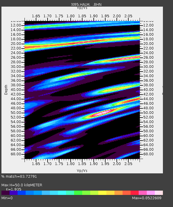
| Estimated Moho Depth: |
50.0 km |
| Estimated Crust Vp/Vs: |
1.93 |
| Assumed Crust Vp: |
6.498 km/s |
| Estimated Crust Vs: |
3.358 km/s |
| Estimated Crust Poisson's Ratio: |
0.32 |
|
| Radial Match: |
83.72791 % |
| Radial Bump: |
400 |
| Transverse Match: |
26.984705 % |
| Transverse Bump: |
400 |
| SOD ConfigId: |
4480 |
| Insert Time: |
2010-03-09 23:37:06.063 +0000 |
| GWidth: |
2.5 |
| Max Bumps: |
400 |
| Tol: |
0.001 |
|

Signal To Noise
| Channel | StoN | STA | LTA |
| XI:HALM: :BHN:19970121T01:54:25.476007Z | 2.2680948 | 2.060422E-7 | 9.0843734E-8 |
| XI:HALM: :BHE:19970121T01:54:25.476007Z | 0.62944263 | 1.432345E-7 | 2.2755768E-7 |
| XI:HALM: :BHZ:19970121T01:54:25.476007Z | 1.6670637 | 2.390282E-7 | 1.4338276E-7 |
| Arrivals |
| Ps | 7.7 SECOND |
| PpPs | 21 SECOND |
| PsPs/PpSs | 29 SECOND |


