You are here: Home > Network List > XI95 - Saudi Arabia Broadband Array Stations List
> Station HALM XI.HALM > Earthquake Result Viewer
HALM XI.HALM - Earthquake Result Viewer
| Earthquake location: |
Kuril Islands |
| Earthquake latitude/longitude: |
44.6/149.4 |
| Earthquake time(UTC): |
1995/12/03 (337) 18:01:08 GMT |
| Earthquake Depth: |
33 km |
| Earthquake Magnitude: |
6.6 MB, 8.0 MS |
| Earthquake Catalog/Contributor: |
WHDF/NEIC |
|
| Network: |
XI Saudi Arabia Broadband Array |
| Station: |
HALM XI.HALM |
| Lat/Lon: |
22.85 N/44.32 E |
| Elevation: |
930 m |
|
| Distance: |
84.3 deg |
| Az: |
296.469 deg |
| Baz: |
43.917 deg |
| Ray Param: |
0.045511868 |
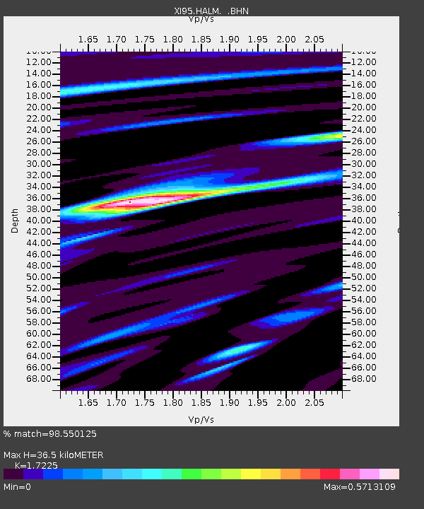
| Estimated Moho Depth: |
36.5 km |
| Estimated Crust Vp/Vs: |
1.72 |
| Assumed Crust Vp: |
6.498 km/s |
| Estimated Crust Vs: |
3.772 km/s |
| Estimated Crust Poisson's Ratio: |
0.25 |
|
| Radial Match: |
98.550125 % |
| Radial Bump: |
400 |
| Transverse Match: |
93.65423 % |
| Transverse Bump: |
400 |
| SOD ConfigId: |
6273 |
| Insert Time: |
2010-03-09 23:37:21.330 +0000 |
| GWidth: |
2.5 |
| Max Bumps: |
400 |
| Tol: |
0.001 |
|

Signal To Noise
| Channel | StoN | STA | LTA |
| XI:HALM: :BHN:19951203T18:13:06.025024Z | 1.2674751 | 1.13049E-8 | 8.919228E-9 |
| XI:HALM: :BHE:19951203T18:13:06.025024Z | 1.4515806 | 9.235189E-9 | 6.3621606E-9 |
| XI:HALM: :BHZ:19951203T18:13:06.025024Z | 3.7801898 | 3.2459155E-8 | 8.586647E-9 |
| Arrivals |
| Ps | 4.2 SECOND |
| PpPs | 15 SECOND |
| PsPs/PpSs | 19 SECOND |


