You are here: Home > Network List > XI95 - Saudi Arabia Broadband Array Stations List
> Station HALM XI.HALM > Earthquake Result Viewer
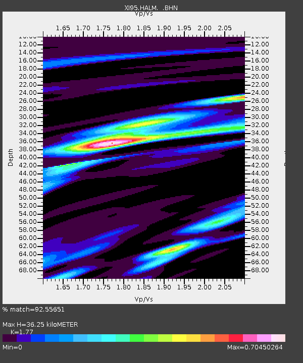
HALM XI.HALM - Earthquake Result Viewer
| Earthquake location: |
Kuril Islands |
| Earthquake latitude/longitude: |
44.2/150.0 |
| Earthquake time(UTC): |
1995/12/10 (344) 22:48:08 GMT |
| Earthquake Depth: |
33 km |
| Earthquake Magnitude: |
5.5 MB, 6.2 MS |
| Earthquake Catalog/Contributor: |
WHDF/NEIC |
|
| Network: |
XI Saudi Arabia Broadband Array |
| Station: |
HALM XI.HALM |
| Lat/Lon: |
22.85 N/44.32 E |
| Elevation: |
930 m |
|
| Distance: |
84.9 deg |
| Az: |
296.881 deg |
| Baz: |
44.03 deg |
| Ray Param: |
0.045139547 |
| Estimated Moho Depth: |
36.25 km |
| Estimated Crust Vp/Vs: |
1.77 |
| Assumed Crust Vp: |
6.498 km/s |
| Estimated Crust Vs: |
3.671 km/s |
| Estimated Crust Poisson's Ratio: |
0.27 |
|
| Radial Match: |
92.55651 % |
| Radial Bump: |
400 |
| Transverse Match: |
74.50749 % |
| Transverse Bump: |
400 |
| SOD ConfigId: |
6273 |
| Insert Time: |
2010-03-09 23:37:25.809 +0000 |
| GWidth: |
2.5 |
| Max Bumps: |
400 |
| Tol: |
0.001 |
|

Signal To Noise
| Channel | StoN | STA | LTA |
| XI:HALM: :BHN:19951210T23:00:08.425Z | 1.8732023 | 1.7819529E-8 | 9.51287E-9 |
| XI:HALM: :BHE:19951210T23:00:08.425Z | 1.8678974 | 1.5470324E-8 | 8.282212E-9 |
| XI:HALM: :BHZ:19951210T23:00:08.425Z | 3.0794497 | 4.9324385E-8 | 1.6017273E-8 |
| Arrivals |
| Ps | 4.4 SECOND |
| PpPs | 15 SECOND |
| PsPs/PpSs | 19 SECOND |


