You are here: Home > Network List > GS - US Geological Survey Networks Stations List
> Station KAN08 Anthony NE Station > Earthquake Result Viewer
KAN08 Anthony NE Station - Earthquake Result Viewer
| Earthquake location: |
Fiji Islands Region |
| Earthquake latitude/longitude: |
-18.2/-178.1 |
| Earthquake time(UTC): |
2018/08/19 (231) 00:55:44 GMT |
| Earthquake Depth: |
538 km |
| Earthquake Magnitude: |
5.6 mb |
| Earthquake Catalog/Contributor: |
NEIC PDE/us |
|
| Network: |
GS US Geological Survey Networks |
| Station: |
KAN08 Anthony NE Station |
| Lat/Lon: |
37.23 N/97.97 W |
| Elevation: |
375 m |
|
| Distance: |
93.3 deg |
| Az: |
51.969 deg |
| Baz: |
249.702 deg |
| Ray Param: |
0.040831205 |
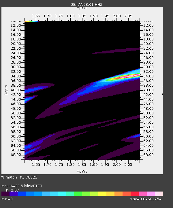
| Estimated Moho Depth: |
33.5 km |
| Estimated Crust Vp/Vs: |
2.07 |
| Assumed Crust Vp: |
6.483 km/s |
| Estimated Crust Vs: |
3.132 km/s |
| Estimated Crust Poisson's Ratio: |
0.35 |
|
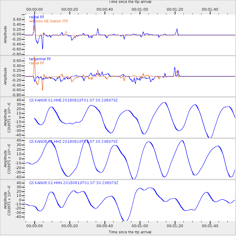
| Radial Match: |
91.78325 % |
| Radial Bump: |
344 |
| Transverse Match: |
70.22141 % |
| Transverse Bump: |
400 |
| SOD ConfigId: |
2825771 |
| Insert Time: |
2018-09-08 00:10:10.871 +0000 |
| GWidth: |
2.5 |
| Max Bumps: |
400 |
| Tol: |
0.001 |
|
Signal To Noise
| Channel | StoN | STA | LTA |
| GS:KAN08:01:HHZ:20180819T01:07:30.298979Z | 0.827428 | 7.695084E-6 | 9.3000035E-6 |
| GS:KAN08:01:HHN:20180819T01:07:30.298979Z | 2.191443 | 2.392277E-5 | 1.0916446E-5 |
| GS:KAN08:01:HHE:20180819T01:07:30.298979Z | 2.0634673 | 2.724131E-5 | 1.3201717E-5 |
| Arrivals |
| Ps | 5.6 SECOND |
| PpPs | 16 SECOND |
| PsPs/PpSs | 21 SECOND |


