You are here: Home > Network List > TX - Texas Seismological Network Stations List
> Station WTFS Witchita Falls > Earthquake Result Viewer
WTFS Witchita Falls - Earthquake Result Viewer

| Earthquake location: |
Fiji Islands Region |
| Earthquake latitude/longitude: |
-18.2/-178.1 |
| Earthquake time(UTC): |
2018/08/19 (231) 00:55:44 GMT |
| Earthquake Depth: |
538 km |
| Earthquake Magnitude: |
5.6 mb |
| Earthquake Catalog/Contributor: |
NEIC PDE/us |
|
| Network: |
TX Texas Seismological Network |
| Station: |
WTFS Witchita Falls |
| Lat/Lon: |
33.77 N/98.46 W |
| Elevation: |
277 m |
|
| Distance: |
91.7 deg |
| Az: |
55.065 deg |
| Baz: |
249.282 deg |
| Ray Param: |
0.041211266 |
| Estimated Moho Depth: |
30.25 km |
| Estimated Crust Vp/Vs: |
2.09 |
| Assumed Crust Vp: |
6.426 km/s |
| Estimated Crust Vs: |
3.071 km/s |
| Estimated Crust Poisson's Ratio: |
0.35 |
|
| Radial Match: |
80.85112 % |
| Radial Bump: |
400 |
| Transverse Match: |
77.01459 % |
| Transverse Bump: |
392 |
| SOD ConfigId: |
2825771 |
| Insert Time: |
2018-09-08 00:12:27.691 +0000 |
| GWidth: |
2.5 |
| Max Bumps: |
400 |
| Tol: |
0.001 |
|
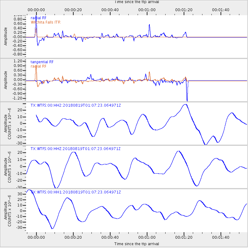
Signal To Noise
| Channel | StoN | STA | LTA |
| TX:WTFS:00:HHZ:20180819T01:07:23.064971Z | 0.47553593 | 8.989865E-6 | 1.8904702E-5 |
| TX:WTFS:00:HH1:20180819T01:07:23.064971Z | 0.644324 | 1.2988381E-5 | 2.0158153E-5 |
| TX:WTFS:00:HH2:20180819T01:07:23.064971Z | 3.8328936 | 1.6587106E-5 | 4.3275677E-6 |
| Arrivals |
| Ps | 5.2 SECOND |
| PpPs | 14 SECOND |
| PsPs/PpSs | 20 SECOND |


