You are here: Home > Network List > XI95 - Saudi Arabia Broadband Array Stations List
> Station RANI XI.RANI > Earthquake Result Viewer
RANI XI.RANI - Earthquake Result Viewer
| Earthquake location: |
Flores Sea |
| Earthquake latitude/longitude: |
-7.1/122.6 |
| Earthquake time(UTC): |
1996/06/17 (169) 11:22:18 GMT |
| Earthquake Depth: |
587 km |
| Earthquake Magnitude: |
6.6 MB, 7.9 UNKNOWN, 7.8 MW |
| Earthquake Catalog/Contributor: |
WHDF/NEIC |
|
| Network: |
XI Saudi Arabia Broadband Array |
| Station: |
RANI XI.RANI |
| Lat/Lon: |
21.31 N/42.78 E |
| Elevation: |
1001 m |
|
| Distance: |
83.2 deg |
| Az: |
292.435 deg |
| Baz: |
100.357 deg |
| Ray Param: |
0.044632155 |
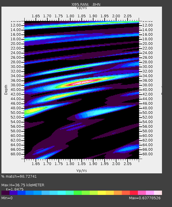
| Estimated Moho Depth: |
36.75 km |
| Estimated Crust Vp/Vs: |
1.85 |
| Assumed Crust Vp: |
6.642 km/s |
| Estimated Crust Vs: |
3.595 km/s |
| Estimated Crust Poisson's Ratio: |
0.29 |
|
| Radial Match: |
98.72741 % |
| Radial Bump: |
327 |
| Transverse Match: |
92.61593 % |
| Transverse Bump: |
400 |
| SOD ConfigId: |
6273 |
| Insert Time: |
2010-03-09 23:39:04.063 +0000 |
| GWidth: |
2.5 |
| Max Bumps: |
400 |
| Tol: |
0.001 |
|

Signal To Noise
| Channel | StoN | STA | LTA |
| XI:RANI: :BHN:19960617T11:33:12.580017Z | 1.8550769 | 1.1533237E-7 | 6.21712E-8 |
| XI:RANI: :BHE:19960617T11:33:12.580017Z | 2.6390088 | 5.067921E-7 | 1.9203881E-7 |
| XI:RANI: :BHZ:19960617T11:33:12.580017Z | 17.192951 | 1.3627247E-6 | 7.926066E-8 |
| Arrivals |
| Ps | 4.8 SECOND |
| PpPs | 15 SECOND |
| PsPs/PpSs | 20 SECOND |


