You are here: Home > Network List > XI95 - Saudi Arabia Broadband Array Stations List
> Station RANI XI.RANI > Earthquake Result Viewer
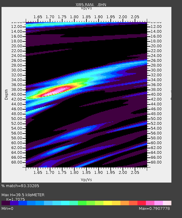
RANI XI.RANI - Earthquake Result Viewer
| Earthquake location: |
Kuril Islands |
| Earthquake latitude/longitude: |
44.3/149.8 |
| Earthquake time(UTC): |
1995/12/10 (344) 22:23:14 GMT |
| Earthquake Depth: |
33 km |
| Earthquake Magnitude: |
5.6 MB, 6.4 MS |
| Earthquake Catalog/Contributor: |
WHDF/NEIC |
|
| Network: |
XI Saudi Arabia Broadband Array |
| Station: |
RANI XI.RANI |
| Lat/Lon: |
21.31 N/42.78 E |
| Elevation: |
1001 m |
|
| Distance: |
86.8 deg |
| Az: |
296.74 deg |
| Baz: |
43.42 deg |
| Ray Param: |
0.043747783 |
| Estimated Moho Depth: |
39.5 km |
| Estimated Crust Vp/Vs: |
1.71 |
| Assumed Crust Vp: |
6.642 km/s |
| Estimated Crust Vs: |
3.89 km/s |
| Estimated Crust Poisson's Ratio: |
0.24 |
|
| Radial Match: |
93.33285 % |
| Radial Bump: |
400 |
| Transverse Match: |
66.27302 % |
| Transverse Bump: |
400 |
| SOD ConfigId: |
6273 |
| Insert Time: |
2010-03-09 23:39:09.707 +0000 |
| GWidth: |
2.5 |
| Max Bumps: |
400 |
| Tol: |
0.001 |
|

Signal To Noise
| Channel | StoN | STA | LTA |
| XI:RANI: :BHN:19951210T22:35:24.405017Z | 1.2352382 | 8.4672834E-8 | 6.854778E-8 |
| XI:RANI: :BHE:19951210T22:35:24.405017Z | 1.0578407 | 1.08102974E-7 | 1.0219212E-7 |
| XI:RANI: :BHZ:19951210T22:35:24.405017Z | 2.6222088 | 3.3815064E-7 | 1.2895642E-7 |
| Arrivals |
| Ps | 4.3 SECOND |
| PpPs | 16 SECOND |
| PsPs/PpSs | 20 SECOND |


