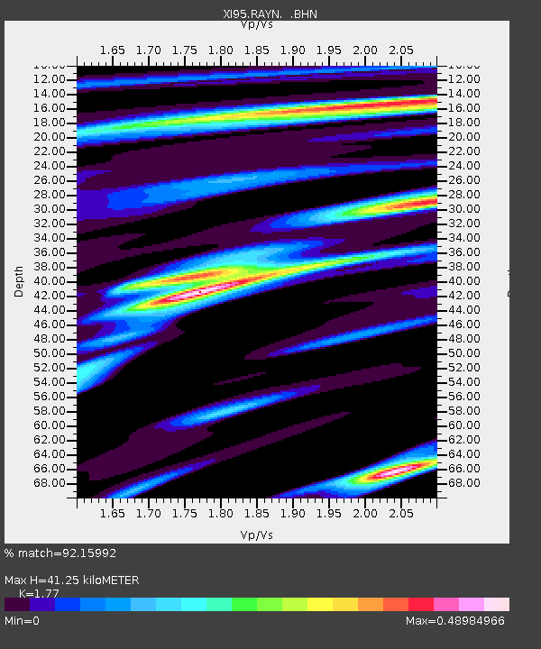
RAYN XI.RAYN - Earthquake Result Viewer

Earthquake location: Irian Jaya Region, Indonesia
Earthquake latitude/longitude: -0.6/135.9
Earthquake time(UTC): 1996/02/17 (048) 14:21:23 GMT
Earthquake Depth: 33 km
Earthquake Magnitude: 5.8 MB, 6.7 MS, 6.7 UNKNOWN, 6.4 MW
Earthquake Catalog/Contributor: WHDF/NEIC
Network: XI Saudi Arabia Broadband Array
Station: RAYN XI.RAYN
Lat/Lon: 23.52 N/45.50 E
Elevation: 792 m
Distance: 90.6 deg
Az: 293.378 deg
Baz: 90.391 deg
Ray Param: 0.041659597
Estimated Moho Depth: 41.25 km
Estimated Crust Vp/Vs: 1.77
Assumed Crust Vp: 6.498 km/s
Estimated Crust Vs: 3.671 km/s
Estimated Crust Poisson's Ratio: 0.27
Radial Match: 92.15992 %
Radial Bump: 400
Transverse Match: 77.519135 %
Transverse Bump: 400
SOD ConfigId: 6273
Insert Time: 2010-03-09 23:40:00.875 +0000
GWidth: 2.5
Max Bumps: 400
Tol: 0.001

Signal To Noise

ChannelStoNSTALTA
XI:RAYN: :BHN:19960217T14:33:51.231006Z0.59817477.575516E-81.2664388E-7
XI:RAYN: :BHE:19960217T14:33:51.231006Z2.72122482.3702607E-78.710272E-8
XI:RAYN: :BHZ:19960217T14:33:51.231006Z9.2863517.921256E-78.529998E-8
Arrivals
Ps5.0 SECOND
PpPs17 SECOND
PsPs/PpSs22 SECOND