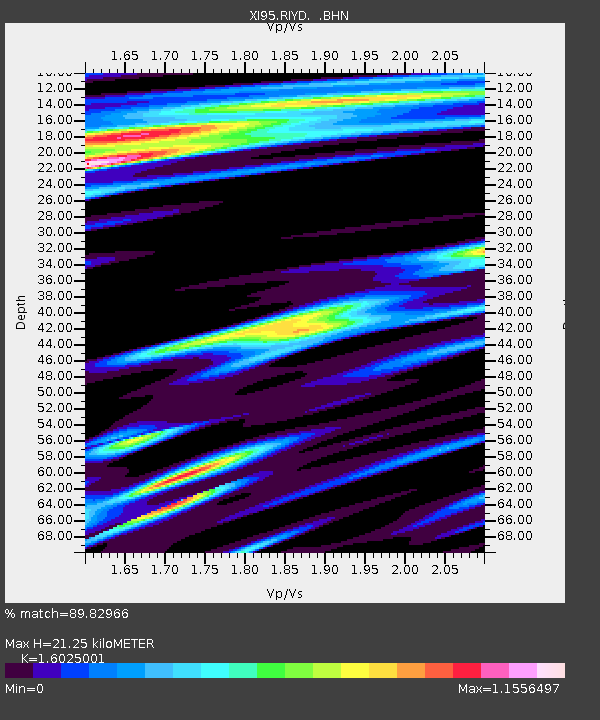
RIYD XI.RIYD - Earthquake Result Viewer

Earthquake location: Minahassa Peninsula, Sulawesi
Earthquake latitude/longitude: 1.0/120.4
Earthquake time(UTC): 1996/07/22 (204) 14:19:35 GMT
Earthquake Depth: 33 km
Earthquake Magnitude: 6.0 MB, 6.9 MS, 7.0 UNKNOWN, 6.9 MW
Earthquake Catalog/Contributor: WHDF/NEIC
Network: XI Saudi Arabia Broadband Array
Station: RIYD XI.RIYD
Lat/Lon: 24.72 N/46.64 E
Elevation: 717 m
Distance: 74.9 deg
Az: 295.226 deg
Baz: 95.958 deg
Ray Param: 0.051986326
Estimated Moho Depth: 21.25 km
Estimated Crust Vp/Vs: 1.60
Assumed Crust Vp: 6.444 km/s
Estimated Crust Vs: 4.021 km/s
Estimated Crust Poisson's Ratio: 0.18
Radial Match: 89.82966 %
Radial Bump: 391
Transverse Match: 77.96222 %
Transverse Bump: 400
SOD ConfigId: 6273
Insert Time: 2010-03-09 23:40:59.264 +0000
GWidth: 2.5
Max Bumps: 400
Tol: 0.001

Signal To Noise

ChannelStoNSTALTA
XI:RIYD: :BHN:19960722T14:30:42.106006Z1.2899172.526296E-71.9584948E-7
XI:RIYD: :BHE:19960722T14:30:42.106006Z1.42195932.927901E-72.0590612E-7
XI:RIYD: :BHZ:19960722T14:30:42.106006Z1.52010979.227309E-86.07016E-8
Arrivals
Ps2.1 SECOND
PpPs8.3 SECOND
PsPs/PpSs10 SECOND