You are here: Home > Network List > GS - US Geological Survey Networks Stations List
> Station OK031 S. Brethren Rd., Cushing, OK, USA > Earthquake Result Viewer
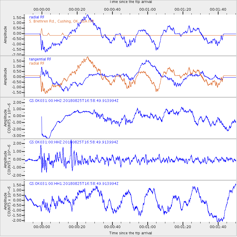
OK031 S. Brethren Rd., Cushing, OK, USA - Earthquake Result Viewer
*The percent match for this event was below the threshold and hence no stack was calculated.
| Earthquake location: |
Fox Islands, Aleutian Islands |
| Earthquake latitude/longitude: |
52.3/-171.2 |
| Earthquake time(UTC): |
2018/08/25 (237) 16:50:04 GMT |
| Earthquake Depth: |
35 km |
| Earthquake Magnitude: |
5.5 Ml |
| Earthquake Catalog/Contributor: |
NEIC PDE/us |
|
| Network: |
GS US Geological Survey Networks |
| Station: |
OK031 S. Brethren Rd., Cushing, OK, USA |
| Lat/Lon: |
35.95 N/96.84 W |
| Elevation: |
290 m |
|
| Distance: |
53.4 deg |
| Az: |
76.587 deg |
| Baz: |
312.573 deg |
| Ray Param: |
$rayparam |
*The percent match for this event was below the threshold and hence was not used in the summary stack. |
|
| Radial Match: |
55.39913 % |
| Radial Bump: |
400 |
| Transverse Match: |
47.837666 % |
| Transverse Bump: |
400 |
| SOD ConfigId: |
2825771 |
| Insert Time: |
2018-09-08 17:03:26.650 +0000 |
| GWidth: |
2.5 |
| Max Bumps: |
400 |
| Tol: |
0.001 |
|
Signal To Noise
| Channel | StoN | STA | LTA |
| GS:OK031:00:HHZ:20180825T16:58:49.913994Z | 13.874345 | 8.0732974E-7 | 5.8188675E-8 |
| GS:OK031:00:HH1:20180825T16:58:49.913994Z | 0.4935986 | 5.253217E-7 | 1.064269E-6 |
| GS:OK031:00:HH2:20180825T16:58:49.913994Z | 0.77895576 | 1.1121584E-6 | 1.4277556E-6 |
| Arrivals |
| Ps | |
| PpPs | |
| PsPs/PpSs | |


