You are here: Home > Network List > CC - Cascade Chain Volcano Monitoring Stations List
> Station KAUT Kautz Creek Helibase > Earthquake Result Viewer
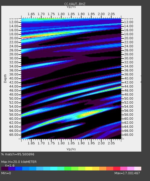
KAUT Kautz Creek Helibase - Earthquake Result Viewer
| Earthquake location: |
Eastern New Guinea Reg., P.N.G. |
| Earthquake latitude/longitude: |
-6.0/147.3 |
| Earthquake time(UTC): |
2022/08/13 (225) 18:57:16 GMT |
| Earthquake Depth: |
52 km |
| Earthquake Magnitude: |
5.9 mww |
| Earthquake Catalog/Contributor: |
NEIC PDE/us |
|
| Network: |
CC Cascade Chain Volcano Monitoring |
| Station: |
KAUT Kautz Creek Helibase |
| Lat/Lon: |
46.73 N/121.86 W |
| Elevation: |
689 m |
|
| Distance: |
94.9 deg |
| Az: |
43.658 deg |
| Baz: |
266.502 deg |
| Ray Param: |
0.040893946 |
| Estimated Moho Depth: |
20.0 km |
| Estimated Crust Vp/Vs: |
1.60 |
| Assumed Crust Vp: |
6.597 km/s |
| Estimated Crust Vs: |
4.123 km/s |
| Estimated Crust Poisson's Ratio: |
0.18 |
|
| Radial Match: |
95.580696 % |
| Radial Bump: |
259 |
| Transverse Match: |
93.468025 % |
| Transverse Bump: |
244 |
| SOD ConfigId: |
28764291 |
| Insert Time: |
2022-08-27 19:08:45.525 +0000 |
| GWidth: |
2.5 |
| Max Bumps: |
400 |
| Tol: |
0.001 |
|

Signal To Noise
| Channel | StoN | STA | LTA |
| CC:KAUT: :BHZ:20220813T19:10:01.899996Z | 1.2159388 | 9.426673E-7 | 7.7525885E-7 |
| CC:KAUT: :BHN:20220813T19:10:01.899996Z | 1.1597016 | 7.582771E-5 | 6.538553E-5 |
| CC:KAUT: :BHE:20220813T19:10:01.899996Z | 1.4402188 | 3.2361666E-5 | 2.2469965E-5 |
| Arrivals |
| Ps | 1.9 SECOND |
| PpPs | 7.7 SECOND |
| PsPs/PpSs | 9.6 SECOND |


