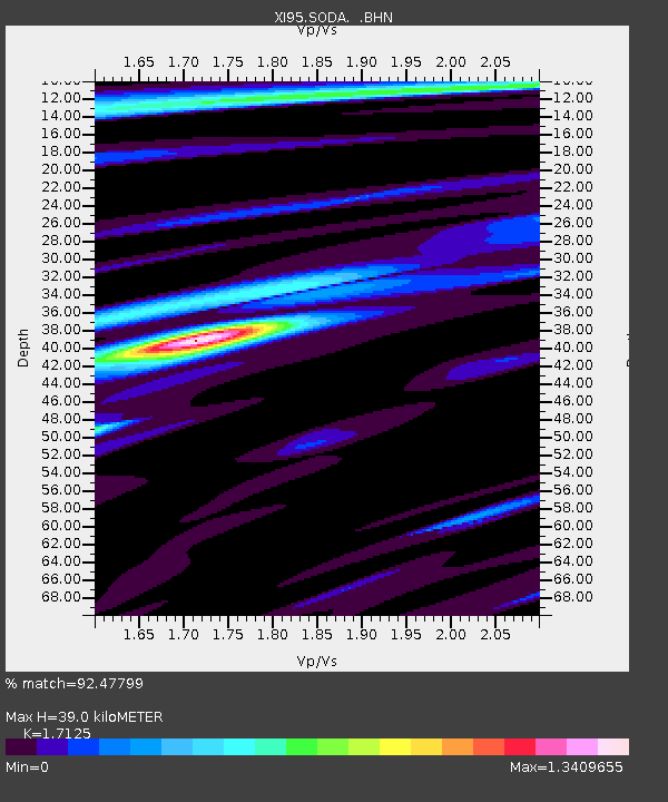
SODA XI.SODA - Earthquake Result Viewer

Earthquake location: Northern Sumatra, Indonesia
Earthquake latitude/longitude: 3.4/97.9
Earthquake time(UTC): 1996/10/10 (284) 15:21:04 GMT
Earthquake Depth: 33 km
Earthquake Magnitude: 5.7 MB, 6.1 MS, 6.3 UNKNOWN, 6.2 MW
Earthquake Catalog/Contributor: WHDF/NEIC
Network: XI Saudi Arabia Broadband Array
Station: SODA XI.SODA
Lat/Lon: 18.29 N/42.38 E
Elevation: 2876 m
Distance: 56.3 deg
Az: 289.62 deg
Baz: 98.25 deg
Ray Param: 0.0641754
Estimated Moho Depth: 39.0 km
Estimated Crust Vp/Vs: 1.71
Assumed Crust Vp: 6.642 km/s
Estimated Crust Vs: 3.878 km/s
Estimated Crust Poisson's Ratio: 0.24
Radial Match: 92.47799 %
Radial Bump: 400
Transverse Match: 86.80741 %
Transverse Bump: 400
SOD ConfigId: 6273
Insert Time: 2010-03-09 23:43:07.410 +0000
GWidth: 2.5
Max Bumps: 400
Tol: 0.001

Signal To Noise

ChannelStoNSTALTA
XI:SODA: :BHN:19961010T15:30:11.431018Z0.61541582.2473793E-83.651806E-8
XI:SODA: :BHE:19961010T15:30:11.431018Z3.5896291.06249665E-72.9599068E-8
XI:SODA: :BHZ:19961010T15:30:11.431018Z4.19071871.6994267E-74.0552155E-8
Arrivals
Ps4.4 SECOND
PpPs15 SECOND
PsPs/PpSs19 SECOND