You are here: Home > Network List > AV - Alaska Volcano Observatory Stations List
> Station KOKL Mount Kliuchef, Korovin Volcano, Alaska > Earthquake Result Viewer
KOKL Mount Kliuchef, Korovin Volcano, Alaska - Earthquake Result Viewer
| Earthquake location: |
Northern Molucca Sea |
| Earthquake latitude/longitude: |
1.8/126.4 |
| Earthquake time(UTC): |
2022/08/14 (226) 02:47:46 GMT |
| Earthquake Depth: |
30 km |
| Earthquake Magnitude: |
5.7 mww |
| Earthquake Catalog/Contributor: |
NEIC PDE/us |
|
| Network: |
AV Alaska Volcano Observatory |
| Station: |
KOKL Mount Kliuchef, Korovin Volcano, Alaska |
| Lat/Lon: |
52.32 N/174.20 W |
| Elevation: |
758 m |
|
| Distance: |
70.3 deg |
| Az: |
34.145 deg |
| Baz: |
246.066 deg |
| Ray Param: |
0.055036284 |
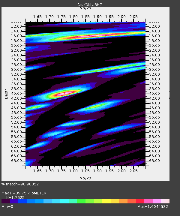
| Estimated Moho Depth: |
39.75 km |
| Estimated Crust Vp/Vs: |
1.76 |
| Assumed Crust Vp: |
5.88 km/s |
| Estimated Crust Vs: |
3.336 km/s |
| Estimated Crust Poisson's Ratio: |
0.26 |
|
| Radial Match: |
90.98352 % |
| Radial Bump: |
336 |
| Transverse Match: |
69.72423 % |
| Transverse Bump: |
388 |
| SOD ConfigId: |
28764291 |
| Insert Time: |
2022-08-28 02:55:37.307 +0000 |
| GWidth: |
2.5 |
| Max Bumps: |
400 |
| Tol: |
0.001 |
|

Signal To Noise
| Channel | StoN | STA | LTA |
| AV:KOKL: :BHZ:20220814T02:58:26.380Z | 9.4213085 | 1.0521002E-6 | 1.11672406E-7 |
| AV:KOKL: :BHN:20220814T02:58:26.380Z | 2.7265267 | 6.873602E-7 | 2.5210105E-7 |
| AV:KOKL: :BHE:20220814T02:58:26.380Z | 8.718182 | 1.2068289E-6 | 1.3842667E-7 |
| Arrivals |
| Ps | 5.3 SECOND |
| PpPs | 18 SECOND |
| PsPs/PpSs | 23 SECOND |


