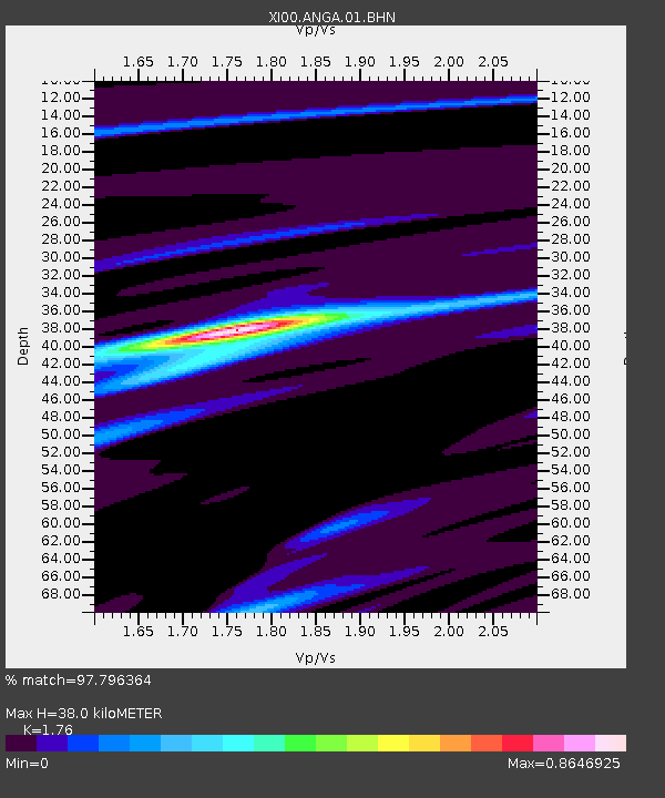
ANGA Namanga - Earthquake Result Viewer

Earthquake location: Banda Sea
Earthquake latitude/longitude: -4.1/123.9
Earthquake time(UTC): 2001/10/19 (292) 03:28:44 GMT
Earthquake Depth: 33 km
Earthquake Magnitude: 6.3 MB, 7.3 MS, 7.5 MW, 7.4 MW
Earthquake Catalog/Contributor: WHDF/NEIC
Network: XI Ethiopia/Kenya Broadband Seismic Experiment
Station: ANGA Namanga
Lat/Lon: 2.50 S/36.80 E
Elevation: 0.0 m
Distance: 86.9 deg
Az: 267.725 deg
Baz: 93.951 deg
Ray Param: 0.043642078
Estimated Moho Depth: 38.0 km
Estimated Crust Vp/Vs: 1.76
Assumed Crust Vp: 6.601 km/s
Estimated Crust Vs: 3.75 km/s
Estimated Crust Poisson's Ratio: 0.26
Radial Match: 97.796364 %
Radial Bump: 211
Transverse Match: 83.88946 %
Transverse Bump: 400
SOD ConfigId: 16820
Insert Time: 2010-03-09 23:46:00.882 +0000
GWidth: 2.5
Max Bumps: 400
Tol: 0.001

Signal To Noise

ChannelStoNSTALTA
XI:ANGA:01:BHN:20011019T03:40:54.894021Z0.89271031.3754781E-71.5407889E-7
XI:ANGA:01:BHE:20011019T03:40:54.894021Z1.54893791.8639315E-71.2033611E-7
XI:ANGA:01:BHZ:20011019T03:40:54.894021Z3.3397542.0771095E-76.2193486E-8
Arrivals
Ps4.5 SECOND
PpPs16 SECOND
PsPs/PpSs20 SECOND