You are here: Home > Network List > US - United States National Seismic Network Stations List
> Station HAWA Hanford, Washington, USA > Earthquake Result Viewer
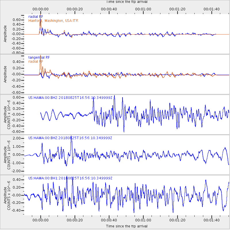
HAWA Hanford, Washington, USA - Earthquake Result Viewer
*The percent match for this event was below the threshold and hence no stack was calculated.
| Earthquake location: |
Fox Islands, Aleutian Islands |
| Earthquake latitude/longitude: |
52.3/-171.2 |
| Earthquake time(UTC): |
2018/08/25 (237) 16:50:04 GMT |
| Earthquake Depth: |
35 km |
| Earthquake Magnitude: |
5.5 Ml |
| Earthquake Catalog/Contributor: |
NEIC PDE/us |
|
| Network: |
US United States National Seismic Network |
| Station: |
HAWA Hanford, Washington, USA |
| Lat/Lon: |
46.39 N/119.53 W |
| Elevation: |
364 m |
|
| Distance: |
33.6 deg |
| Az: |
79.104 deg |
| Baz: |
299.369 deg |
| Ray Param: |
$rayparam |
*The percent match for this event was below the threshold and hence was not used in the summary stack. |
|
| Radial Match: |
79.678116 % |
| Radial Bump: |
400 |
| Transverse Match: |
72.86412 % |
| Transverse Bump: |
400 |
| SOD ConfigId: |
2825771 |
| Insert Time: |
2018-09-08 17:12:06.275 +0000 |
| GWidth: |
2.5 |
| Max Bumps: |
400 |
| Tol: |
0.001 |
|
Signal To Noise
| Channel | StoN | STA | LTA |
| US:HAWA:00:BHZ:20180825T16:56:10.349999Z | 8.804911 | 5.7470834E-7 | 6.5271344E-8 |
| US:HAWA:00:BH1:20180825T16:56:10.349999Z | 4.7716007 | 1.5734794E-7 | 3.2975926E-8 |
| US:HAWA:00:BH2:20180825T16:56:10.349999Z | 2.559424 | 2.1712589E-7 | 8.483389E-8 |
| Arrivals |
| Ps | |
| PpPs | |
| PsPs/PpSs | |


