You are here: Home > Network List > AK - Alaska Regional Network Stations List
> Station R18K Karluk, AK, USA > Earthquake Result Viewer
R18K Karluk, AK, USA - Earthquake Result Viewer
| Earthquake location: |
South Of Kermadec Islands |
| Earthquake latitude/longitude: |
-32.9/-178.0 |
| Earthquake time(UTC): |
2022/08/14 (226) 13:44:22 GMT |
| Earthquake Depth: |
33 km |
| Earthquake Magnitude: |
6.8 Mi |
| Earthquake Catalog/Contributor: |
NEIC PDE/at |
|
| Network: |
AK Alaska Regional Network |
| Station: |
R18K Karluk, AK, USA |
| Lat/Lon: |
57.57 N/154.45 W |
| Elevation: |
39 m |
|
| Distance: |
92.3 deg |
| Az: |
12.443 deg |
| Baz: |
199.656 deg |
| Ray Param: |
0.041475594 |
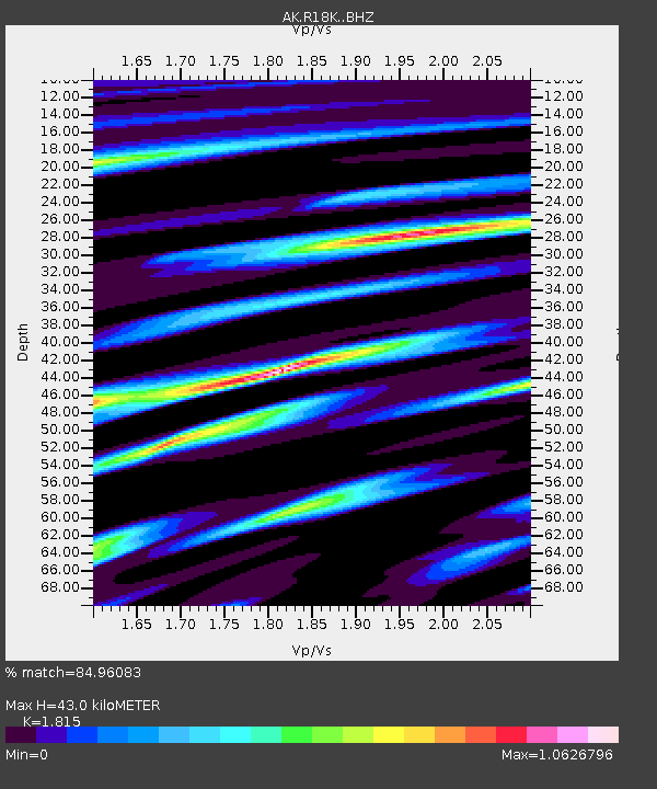
| Estimated Moho Depth: |
43.0 km |
| Estimated Crust Vp/Vs: |
1.82 |
| Assumed Crust Vp: |
6.24 km/s |
| Estimated Crust Vs: |
3.438 km/s |
| Estimated Crust Poisson's Ratio: |
0.28 |
|
| Radial Match: |
84.96083 % |
| Radial Bump: |
400 |
| Transverse Match: |
80.749146 % |
| Transverse Bump: |
400 |
| SOD ConfigId: |
28764291 |
| Insert Time: |
2022-08-28 13:47:54.044 +0000 |
| GWidth: |
2.5 |
| Max Bumps: |
400 |
| Tol: |
0.001 |
|

Signal To Noise
| Channel | StoN | STA | LTA |
| AK:R18K: :BHZ:20220814T13:56:57.400024Z | 14.562668 | 9.715734E-7 | 6.6716716E-8 |
| AK:R18K: :BHN:20220814T13:56:57.400024Z | 3.3349295 | 3.2167634E-7 | 9.6456716E-8 |
| AK:R18K: :BHE:20220814T13:56:57.400024Z | 3.8343925 | 2.8541655E-7 | 7.443592E-8 |
| Arrivals |
| Ps | 5.7 SECOND |
| PpPs | 19 SECOND |
| PsPs/PpSs | 25 SECOND |


