You are here: Home > Network List > AV - Alaska Volcano Observatory Stations List
> Station KIMD MID Benchmark, Kanaga Volcano, Alaska > Earthquake Result Viewer
KIMD MID Benchmark, Kanaga Volcano, Alaska - Earthquake Result Viewer
| Earthquake location: |
South Of Kermadec Islands |
| Earthquake latitude/longitude: |
-32.9/-178.0 |
| Earthquake time(UTC): |
2022/08/14 (226) 13:44:22 GMT |
| Earthquake Depth: |
33 km |
| Earthquake Magnitude: |
6.8 Mi |
| Earthquake Catalog/Contributor: |
NEIC PDE/at |
|
| Network: |
AV Alaska Volcano Observatory |
| Station: |
KIMD MID Benchmark, Kanaga Volcano, Alaska |
| Lat/Lon: |
51.76 N/177.24 W |
| Elevation: |
183 m |
|
| Distance: |
84.3 deg |
| Az: |
0.477 deg |
| Baz: |
180.645 deg |
| Ray Param: |
0.045539517 |
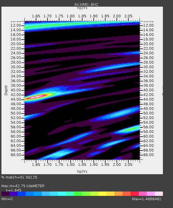
| Estimated Moho Depth: |
42.75 km |
| Estimated Crust Vp/Vs: |
1.64 |
| Assumed Crust Vp: |
5.88 km/s |
| Estimated Crust Vs: |
3.575 km/s |
| Estimated Crust Poisson's Ratio: |
0.21 |
|
| Radial Match: |
81.56125 % |
| Radial Bump: |
400 |
| Transverse Match: |
75.92067 % |
| Transverse Bump: |
400 |
| SOD ConfigId: |
28764291 |
| Insert Time: |
2022-08-28 13:50:33.301 +0000 |
| GWidth: |
2.5 |
| Max Bumps: |
400 |
| Tol: |
0.001 |
|

Signal To Noise
| Channel | StoN | STA | LTA |
| AV:KIMD: :BHZ:20220814T13:56:19.359009Z | 8.95191 | 1.7119354E-6 | 1.9123688E-7 |
| AV:KIMD: :BHN:20220814T13:56:19.359009Z | 3.6417248 | 5.788956E-7 | 1.5896192E-7 |
| AV:KIMD: :BHE:20220814T13:56:19.359009Z | 1.0823518 | 1.8677267E-7 | 1.7256188E-7 |
| Arrivals |
| Ps | 4.8 SECOND |
| PpPs | 19 SECOND |
| PsPs/PpSs | 24 SECOND |


