You are here: Home > Network List > AV - Alaska Volcano Observatory Stations List
> Station Q20K Shuyak Island, AK, USA > Earthquake Result Viewer
Q20K Shuyak Island, AK, USA - Earthquake Result Viewer
| Earthquake location: |
South Of Kermadec Islands |
| Earthquake latitude/longitude: |
-32.9/-178.0 |
| Earthquake time(UTC): |
2022/08/14 (226) 13:44:22 GMT |
| Earthquake Depth: |
33 km |
| Earthquake Magnitude: |
6.8 Mi |
| Earthquake Catalog/Contributor: |
NEIC PDE/at |
|
| Network: |
AV Alaska Volcano Observatory |
| Station: |
Q20K Shuyak Island, AK, USA |
| Lat/Lon: |
58.61 N/152.39 W |
| Elevation: |
180 m |
|
| Distance: |
93.6 deg |
| Az: |
13.101 deg |
| Baz: |
201.366 deg |
| Ray Param: |
0.041212372 |
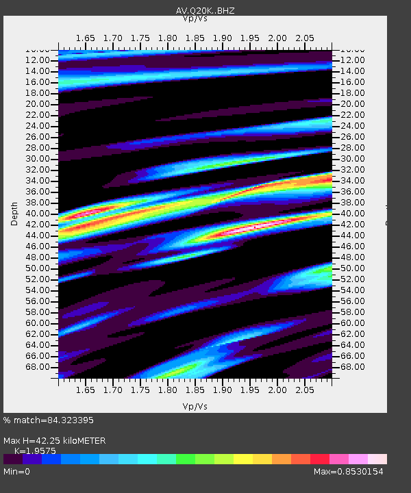
| Estimated Moho Depth: |
42.25 km |
| Estimated Crust Vp/Vs: |
1.96 |
| Assumed Crust Vp: |
5.989 km/s |
| Estimated Crust Vs: |
3.06 km/s |
| Estimated Crust Poisson's Ratio: |
0.32 |
|
| Radial Match: |
84.323395 % |
| Radial Bump: |
400 |
| Transverse Match: |
62.752872 % |
| Transverse Bump: |
400 |
| SOD ConfigId: |
28764291 |
| Insert Time: |
2022-08-28 13:51:26.029 +0000 |
| GWidth: |
2.5 |
| Max Bumps: |
400 |
| Tol: |
0.001 |
|

Signal To Noise
| Channel | StoN | STA | LTA |
| AV:Q20K: :BHZ:20220814T13:57:03.650024Z | 6.3137884 | 8.776193E-7 | 1.3900043E-7 |
| AV:Q20K: :BHN:20220814T13:57:03.650024Z | 2.9096704 | 3.37467E-7 | 1.1598118E-7 |
| AV:Q20K: :BHE:20220814T13:57:03.650024Z | 1.1179903 | 1.577167E-7 | 1.4107162E-7 |
| Arrivals |
| Ps | 6.9 SECOND |
| PpPs | 21 SECOND |
| PsPs/PpSs | 27 SECOND |


