You are here: Home > Network List > UU - University of Utah Regional Network Stations List
> Station SPU South Promontory Point, UT, USA > Earthquake Result Viewer
SPU South Promontory Point, UT, USA - Earthquake Result Viewer
| Earthquake location: |
Fox Islands, Aleutian Islands |
| Earthquake latitude/longitude: |
52.3/-171.2 |
| Earthquake time(UTC): |
2018/08/25 (237) 16:50:04 GMT |
| Earthquake Depth: |
35 km |
| Earthquake Magnitude: |
5.5 Ml |
| Earthquake Catalog/Contributor: |
NEIC PDE/us |
|
| Network: |
UU University of Utah Regional Network |
| Station: |
SPU South Promontory Point, UT, USA |
| Lat/Lon: |
41.31 N/112.45 W |
| Elevation: |
2086 m |
|
| Distance: |
40.6 deg |
| Az: |
81.571 deg |
| Baz: |
306.239 deg |
| Ray Param: |
0.07422597 |
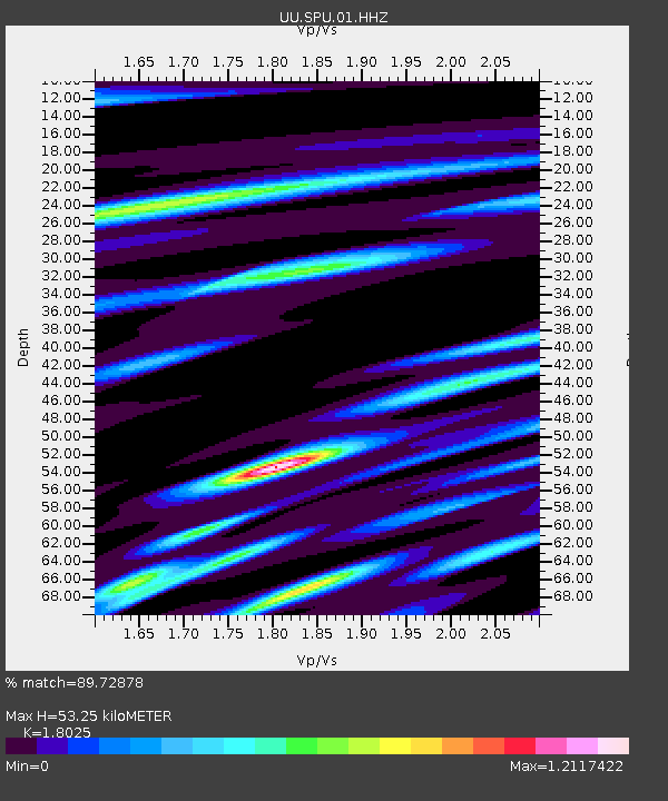
| Estimated Moho Depth: |
53.25 km |
| Estimated Crust Vp/Vs: |
1.80 |
| Assumed Crust Vp: |
6.276 km/s |
| Estimated Crust Vs: |
3.482 km/s |
| Estimated Crust Poisson's Ratio: |
0.28 |
|
| Radial Match: |
89.72878 % |
| Radial Bump: |
400 |
| Transverse Match: |
64.28505 % |
| Transverse Bump: |
400 |
| SOD ConfigId: |
2825771 |
| Insert Time: |
2018-09-08 17:14:16.755 +0000 |
| GWidth: |
2.5 |
| Max Bumps: |
400 |
| Tol: |
0.001 |
|

Signal To Noise
| Channel | StoN | STA | LTA |
| UU:SPU:01:HHZ:20180825T16:57:10.094994Z | 7.4157333 | 1.3368106E-8 | 1.802668E-9 |
| UU:SPU:01:HHN:20180825T16:57:10.094994Z | 3.3738673 | 7.770068E-9 | 2.3030153E-9 |
| UU:SPU:01:HHE:20180825T16:57:10.094994Z | 2.183179 | 7.2371233E-9 | 3.3149472E-9 |
| Arrivals |
| Ps | 7.3 SECOND |
| PpPs | 22 SECOND |
| PsPs/PpSs | 30 SECOND |


