You are here: Home > Network List > AV - Alaska Volcano Observatory Stations List
> Station KAPH Katmai Pasha, Alaska > Earthquake Result Viewer
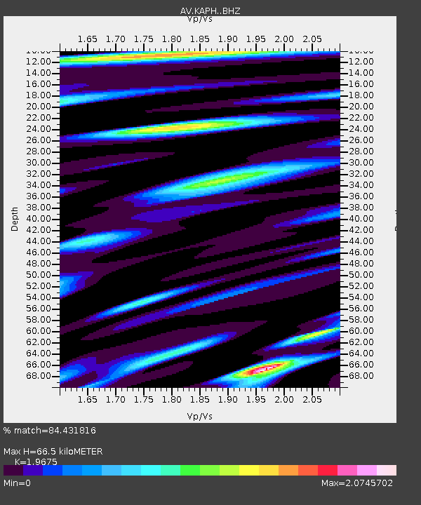
KAPH Katmai Pasha, Alaska - Earthquake Result Viewer
| Earthquake location: |
South Of Kermadec Islands |
| Earthquake latitude/longitude: |
-32.9/-178.0 |
| Earthquake time(UTC): |
2022/08/14 (226) 13:44:22 GMT |
| Earthquake Depth: |
33 km |
| Earthquake Magnitude: |
6.8 Mi |
| Earthquake Catalog/Contributor: |
NEIC PDE/at |
|
| Network: |
AV Alaska Volcano Observatory |
| Station: |
KAPH Katmai Pasha, Alaska |
| Lat/Lon: |
58.60 N/154.35 W |
| Elevation: |
907 m |
|
| Distance: |
93.3 deg |
| Az: |
12.146 deg |
| Baz: |
199.758 deg |
| Ray Param: |
0.041290976 |
| Estimated Moho Depth: |
66.5 km |
| Estimated Crust Vp/Vs: |
1.97 |
| Assumed Crust Vp: |
6.438 km/s |
| Estimated Crust Vs: |
3.272 km/s |
| Estimated Crust Poisson's Ratio: |
0.33 |
|
| Radial Match: |
84.431816 % |
| Radial Bump: |
400 |
| Transverse Match: |
73.83947 % |
| Transverse Bump: |
400 |
| SOD ConfigId: |
28764291 |
| Insert Time: |
2022-08-28 13:52:15.408 +0000 |
| GWidth: |
2.5 |
| Max Bumps: |
400 |
| Tol: |
0.001 |
|

Signal To Noise
| Channel | StoN | STA | LTA |
| AV:KAPH: :BHZ:20220814T13:57:01.939026Z | 13.051543 | 7.406233E-7 | 5.6746032E-8 |
| AV:KAPH: :BHN:20220814T13:57:01.939026Z | 3.4627926 | 2.508706E-7 | 7.244748E-8 |
| AV:KAPH: :BHE:20220814T13:57:01.939026Z | 2.3385308 | 1.7020469E-7 | 7.278275E-8 |
| Arrivals |
| Ps | 10 SECOND |
| PpPs | 30 SECOND |
| PsPs/PpSs | 40 SECOND |


