You are here: Home > Network List > CC - Cascade Chain Volcano Monitoring Stations List
> Station KWBU Kawak Butte > Earthquake Result Viewer
KWBU Kawak Butte - Earthquake Result Viewer
| Earthquake location: |
South Of Kermadec Islands |
| Earthquake latitude/longitude: |
-32.9/-178.0 |
| Earthquake time(UTC): |
2022/08/14 (226) 13:44:22 GMT |
| Earthquake Depth: |
33 km |
| Earthquake Magnitude: |
6.8 Mi |
| Earthquake Catalog/Contributor: |
NEIC PDE/at |
|
| Network: |
CC Cascade Chain Volcano Monitoring |
| Station: |
KWBU Kawak Butte |
| Lat/Lon: |
43.75 N/121.31 W |
| Elevation: |
1783 m |
|
| Distance: |
92.2 deg |
| Az: |
37.302 deg |
| Baz: |
224.713 deg |
| Ray Param: |
0.04149503 |
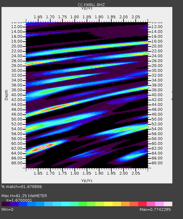
| Estimated Moho Depth: |
61.25 km |
| Estimated Crust Vp/Vs: |
1.67 |
| Assumed Crust Vp: |
6.597 km/s |
| Estimated Crust Vs: |
3.951 km/s |
| Estimated Crust Poisson's Ratio: |
0.22 |
|
| Radial Match: |
81.678986 % |
| Radial Bump: |
400 |
| Transverse Match: |
54.242775 % |
| Transverse Bump: |
400 |
| SOD ConfigId: |
28764291 |
| Insert Time: |
2022-08-28 13:54:38.055 +0000 |
| GWidth: |
2.5 |
| Max Bumps: |
400 |
| Tol: |
0.001 |
|

Signal To Noise
| Channel | StoN | STA | LTA |
| CC:KWBU: :BHZ:20220814T13:56:56.859985Z | 11.918624 | 7.3287276E-7 | 6.1489715E-8 |
| CC:KWBU: :BHN:20220814T13:56:56.859985Z | 4.068997 | 1.9463033E-7 | 4.7832508E-8 |
| CC:KWBU: :BHE:20220814T13:56:56.859985Z | 1.5874641 | 1.04280694E-7 | 6.569012E-8 |
| Arrivals |
| Ps | 6.4 SECOND |
| PpPs | 24 SECOND |
| PsPs/PpSs | 31 SECOND |


