You are here: Home > Network List > CC - Cascade Chain Volcano Monitoring Stations List
> Station LSON Lamberson Butte > Earthquake Result Viewer
LSON Lamberson Butte - Earthquake Result Viewer
| Earthquake location: |
South Of Kermadec Islands |
| Earthquake latitude/longitude: |
-32.9/-178.0 |
| Earthquake time(UTC): |
2022/08/14 (226) 13:44:22 GMT |
| Earthquake Depth: |
33 km |
| Earthquake Magnitude: |
6.8 Mi |
| Earthquake Catalog/Contributor: |
NEIC PDE/at |
|
| Network: |
CC Cascade Chain Volcano Monitoring |
| Station: |
LSON Lamberson Butte |
| Lat/Lon: |
45.36 N/121.65 W |
| Elevation: |
1881 m |
|
| Distance: |
93.1 deg |
| Az: |
36.001 deg |
| Baz: |
224.538 deg |
| Ray Param: |
0.041317996 |
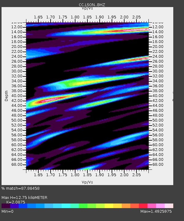
| Estimated Moho Depth: |
12.75 km |
| Estimated Crust Vp/Vs: |
2.09 |
| Assumed Crust Vp: |
6.597 km/s |
| Estimated Crust Vs: |
3.16 km/s |
| Estimated Crust Poisson's Ratio: |
0.35 |
|
| Radial Match: |
87.86458 % |
| Radial Bump: |
400 |
| Transverse Match: |
83.6908 % |
| Transverse Bump: |
400 |
| SOD ConfigId: |
28764291 |
| Insert Time: |
2022-08-28 13:54:38.608 +0000 |
| GWidth: |
2.5 |
| Max Bumps: |
400 |
| Tol: |
0.001 |
|

Signal To Noise
| Channel | StoN | STA | LTA |
| CC:LSON: :BHZ:20220814T13:57:01.340027Z | 16.56559 | 8.229084E-7 | 4.9675766E-8 |
| CC:LSON: :BHN:20220814T13:57:01.340027Z | 3.5248656 | 3.300254E-7 | 9.36278E-8 |
| CC:LSON: :BHE:20220814T13:57:01.340027Z | 1.7542411 | 2.305809E-7 | 1.3144196E-7 |
| Arrivals |
| Ps | 2.1 SECOND |
| PpPs | 5.9 SECOND |
| PsPs/PpSs | 8.0 SECOND |


