You are here: Home > Network List > CC - Cascade Chain Volcano Monitoring Stations List
> Station UNFR Upper North Fork Repeater > Earthquake Result Viewer
UNFR Upper North Fork Repeater - Earthquake Result Viewer
| Earthquake location: |
South Of Kermadec Islands |
| Earthquake latitude/longitude: |
-32.9/-178.0 |
| Earthquake time(UTC): |
2022/08/14 (226) 13:44:22 GMT |
| Earthquake Depth: |
33 km |
| Earthquake Magnitude: |
6.8 Mi |
| Earthquake Catalog/Contributor: |
NEIC PDE/at |
|
| Network: |
CC Cascade Chain Volcano Monitoring |
| Station: |
UNFR Upper North Fork Repeater |
| Lat/Lon: |
46.27 N/122.29 W |
| Elevation: |
884 m |
|
| Distance: |
93.5 deg |
| Az: |
35.039 deg |
| Baz: |
224.133 deg |
| Ray Param: |
0.041248348 |
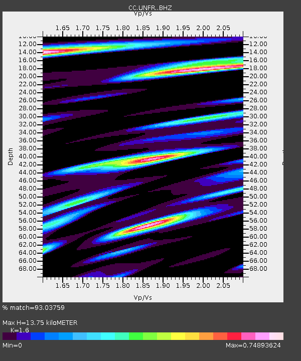
| Estimated Moho Depth: |
13.75 km |
| Estimated Crust Vp/Vs: |
1.60 |
| Assumed Crust Vp: |
6.566 km/s |
| Estimated Crust Vs: |
4.104 km/s |
| Estimated Crust Poisson's Ratio: |
0.18 |
|
| Radial Match: |
93.03759 % |
| Radial Bump: |
400 |
| Transverse Match: |
89.18485 % |
| Transverse Bump: |
399 |
| SOD ConfigId: |
28764291 |
| Insert Time: |
2022-08-28 13:55:22.881 +0000 |
| GWidth: |
2.5 |
| Max Bumps: |
400 |
| Tol: |
0.001 |
|

Signal To Noise
| Channel | StoN | STA | LTA |
| CC:UNFR: :BHZ:20220814T13:57:02.880005Z | 18.09155 | 7.681519E-7 | 4.2459153E-8 |
| CC:UNFR: :BHN:20220814T13:57:02.880005Z | 5.6883135 | 1.9854866E-7 | 3.4904662E-8 |
| CC:UNFR: :BHE:20220814T13:57:02.880005Z | 3.9640055 | 1.7861666E-7 | 4.5059643E-8 |
| Arrivals |
| Ps | 1.3 SECOND |
| PpPs | 5.3 SECOND |
| PsPs/PpSs | 6.6 SECOND |


