You are here: Home > Network List > CI - Caltech Regional Seismic Network Stations List
> Station IRM Iron Mountain Pumping Station, Eagle Mtn., CA, USA > Earthquake Result Viewer
IRM Iron Mountain Pumping Station, Eagle Mtn., CA, USA - Earthquake Result Viewer
| Earthquake location: |
South Of Kermadec Islands |
| Earthquake latitude/longitude: |
-32.9/-178.0 |
| Earthquake time(UTC): |
2022/08/14 (226) 13:44:22 GMT |
| Earthquake Depth: |
33 km |
| Earthquake Magnitude: |
6.8 Mi |
| Earthquake Catalog/Contributor: |
NEIC PDE/at |
|
| Network: |
CI Caltech Regional Seismic Network |
| Station: |
IRM Iron Mountain Pumping Station, Eagle Mtn., CA, USA |
| Lat/Lon: |
34.16 N/115.15 W |
| Elevation: |
567 m |
|
| Distance: |
89.1 deg |
| Az: |
47.562 deg |
| Baz: |
228.479 deg |
| Ray Param: |
0.042080328 |
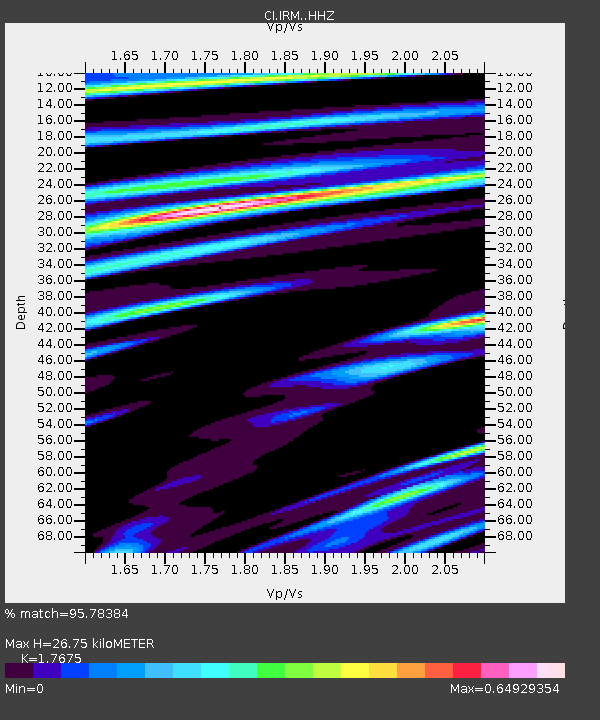
| Estimated Moho Depth: |
26.75 km |
| Estimated Crust Vp/Vs: |
1.77 |
| Assumed Crust Vp: |
6.276 km/s |
| Estimated Crust Vs: |
3.551 km/s |
| Estimated Crust Poisson's Ratio: |
0.26 |
|
| Radial Match: |
95.78384 % |
| Radial Bump: |
367 |
| Transverse Match: |
90.29487 % |
| Transverse Bump: |
400 |
| SOD ConfigId: |
28764291 |
| Insert Time: |
2022-08-28 13:56:18.255 +0000 |
| GWidth: |
2.5 |
| Max Bumps: |
400 |
| Tol: |
0.001 |
|
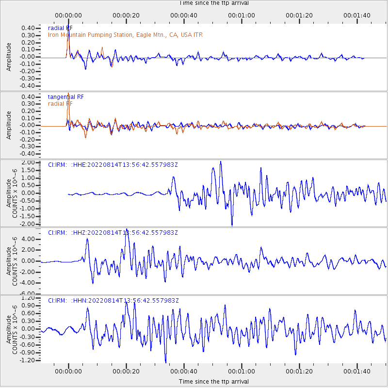
Signal To Noise
| Channel | StoN | STA | LTA |
| CI:IRM: :HHZ:20220814T13:56:42.557983Z | 2.6916156 | 2.5927136E-7 | 9.632555E-8 |
| CI:IRM: :HHN:20220814T13:56:42.557983Z | 1.1342859 | 9.4937604E-8 | 8.3698126E-8 |
| CI:IRM: :HHE:20220814T13:56:42.557983Z | 1.9422454 | 1.0579179E-7 | 5.4468813E-8 |
| Arrivals |
| Ps | 3.3 SECOND |
| PpPs | 12 SECOND |
| PsPs/PpSs | 15 SECOND |


