You are here: Home > Network List > CI - Caltech Regional Seismic Network Stations List
> Station MPP McPhearson Peak > Earthquake Result Viewer
MPP McPhearson Peak - Earthquake Result Viewer
| Earthquake location: |
South Of Kermadec Islands |
| Earthquake latitude/longitude: |
-32.9/-178.0 |
| Earthquake time(UTC): |
2022/08/14 (226) 13:44:22 GMT |
| Earthquake Depth: |
33 km |
| Earthquake Magnitude: |
6.8 Mi |
| Earthquake Catalog/Contributor: |
NEIC PDE/at |
|
| Network: |
CI Caltech Regional Seismic Network |
| Station: |
MPP McPhearson Peak |
| Lat/Lon: |
34.89 N/119.81 W |
| Elevation: |
1739 m |
|
| Distance: |
86.7 deg |
| Az: |
44.402 deg |
| Baz: |
225.729 deg |
| Ray Param: |
0.04378738 |
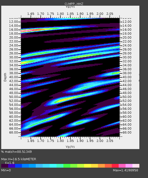
| Estimated Moho Depth: |
16.5 km |
| Estimated Crust Vp/Vs: |
1.60 |
| Assumed Crust Vp: |
6.1 km/s |
| Estimated Crust Vs: |
3.812 km/s |
| Estimated Crust Poisson's Ratio: |
0.18 |
|
| Radial Match: |
88.51349 % |
| Radial Bump: |
400 |
| Transverse Match: |
81.860466 % |
| Transverse Bump: |
400 |
| SOD ConfigId: |
28764291 |
| Insert Time: |
2022-08-28 13:56:32.662 +0000 |
| GWidth: |
2.5 |
| Max Bumps: |
400 |
| Tol: |
0.001 |
|
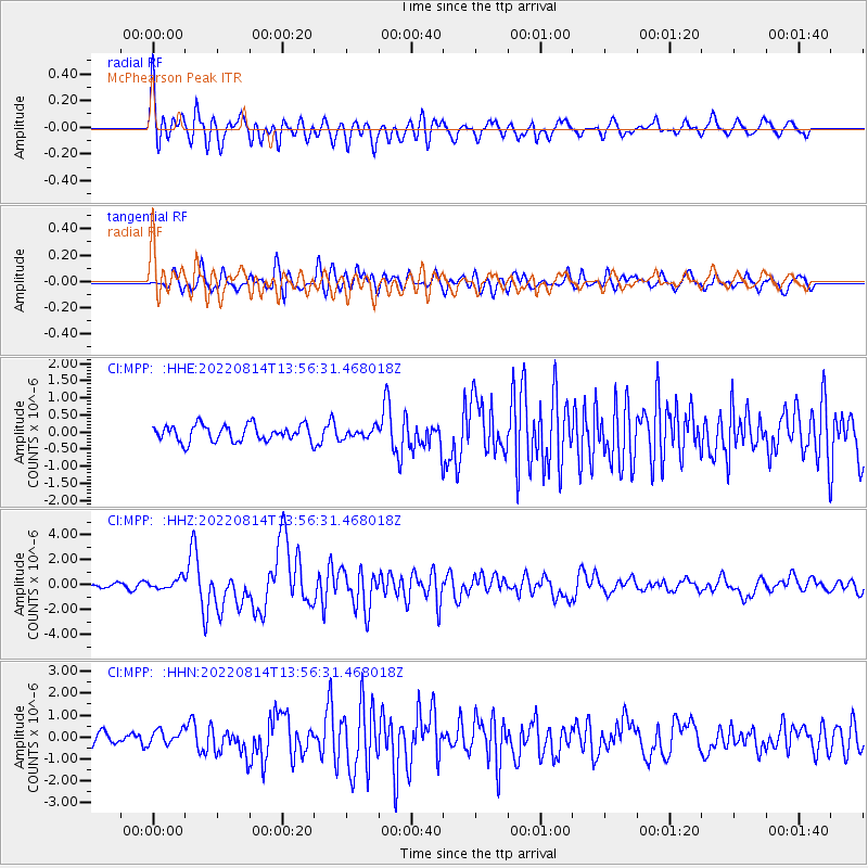
Signal To Noise
| Channel | StoN | STA | LTA |
| CI:MPP: :HHZ:20220814T13:56:31.468018Z | 2.9832008 | 4.1255353E-7 | 1.3829225E-7 |
| CI:MPP: :HHN:20220814T13:56:31.468018Z | 1.0368394 | 3.4714262E-7 | 3.348085E-7 |
| CI:MPP: :HHE:20220814T13:56:31.468018Z | 0.6037225 | 1.4311325E-7 | 2.370514E-7 |
| Arrivals |
| Ps | 1.7 SECOND |
| PpPs | 6.9 SECOND |
| PsPs/PpSs | 8.5 SECOND |


