You are here: Home > Network List > UO - University of Oregon Regional Network Stations List
> Station DRAN Drain, OR, USA > Earthquake Result Viewer
DRAN Drain, OR, USA - Earthquake Result Viewer
| Earthquake location: |
South Of Kermadec Islands |
| Earthquake latitude/longitude: |
-32.9/-178.0 |
| Earthquake time(UTC): |
2022/08/14 (226) 13:44:22 GMT |
| Earthquake Depth: |
33 km |
| Earthquake Magnitude: |
6.8 Mi |
| Earthquake Catalog/Contributor: |
NEIC PDE/at |
|
| Network: |
UO University of Oregon Regional Network |
| Station: |
DRAN Drain, OR, USA |
| Lat/Lon: |
43.70 N/123.35 W |
| Elevation: |
141 m |
|
| Distance: |
91.1 deg |
| Az: |
36.278 deg |
| Baz: |
223.339 deg |
| Ray Param: |
0.041640785 |
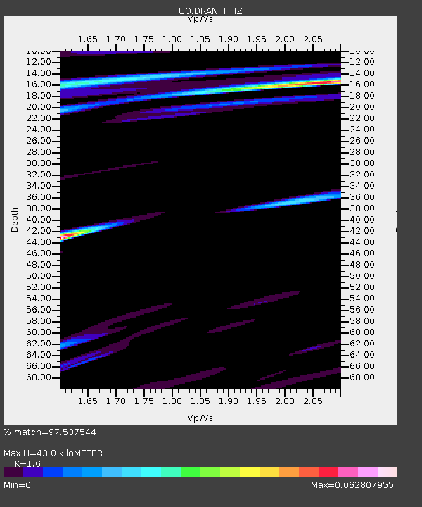
| Estimated Moho Depth: |
43.0 km |
| Estimated Crust Vp/Vs: |
1.60 |
| Assumed Crust Vp: |
6.522 km/s |
| Estimated Crust Vs: |
4.076 km/s |
| Estimated Crust Poisson's Ratio: |
0.18 |
|
| Radial Match: |
97.537544 % |
| Radial Bump: |
159 |
| Transverse Match: |
97.53754 % |
| Transverse Bump: |
159 |
| SOD ConfigId: |
28764291 |
| Insert Time: |
2022-08-28 14:06:04.804 +0000 |
| GWidth: |
2.5 |
| Max Bumps: |
400 |
| Tol: |
0.001 |
|

Signal To Noise
| Channel | StoN | STA | LTA |
| UO:DRAN: :HHZ:20220814T13:56:51.929993Z | 6.24637 | 3.672058E-7 | 5.8787073E-8 |
| UO:DRAN: :HHN:20220814T13:56:51.929993Z | 4.721041 | 4.137576E-7 | 8.764117E-8 |
| $trig.getChannelId() | $trig.getValue() | $trig.getSTA() | $trig.getLTA() |
| Arrivals |
| Ps | 4.1 SECOND |
| PpPs | 17 SECOND |
| PsPs/PpSs | 21 SECOND |


