You are here: Home > Network List > UO - University of Oregon Regional Network Stations List
> Station VINO Umpqua, OR, USA > Earthquake Result Viewer
VINO Umpqua, OR, USA - Earthquake Result Viewer
| Earthquake location: |
South Of Kermadec Islands |
| Earthquake latitude/longitude: |
-32.9/-178.0 |
| Earthquake time(UTC): |
2022/08/14 (226) 13:44:22 GMT |
| Earthquake Depth: |
33 km |
| Earthquake Magnitude: |
6.8 Mi |
| Earthquake Catalog/Contributor: |
NEIC PDE/at |
|
| Network: |
UO University of Oregon Regional Network |
| Station: |
VINO Umpqua, OR, USA |
| Lat/Lon: |
43.43 N/123.42 W |
| Elevation: |
319 m |
|
| Distance: |
90.9 deg |
| Az: |
36.424 deg |
| Baz: |
223.286 deg |
| Ray Param: |
0.041664593 |
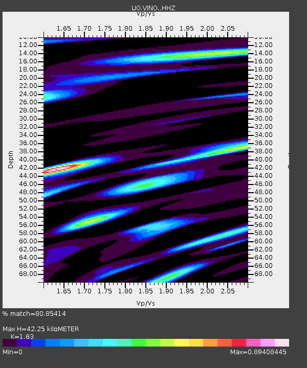
| Estimated Moho Depth: |
42.25 km |
| Estimated Crust Vp/Vs: |
1.63 |
| Assumed Crust Vp: |
6.522 km/s |
| Estimated Crust Vs: |
4.001 km/s |
| Estimated Crust Poisson's Ratio: |
0.20 |
|
| Radial Match: |
80.85414 % |
| Radial Bump: |
400 |
| Transverse Match: |
67.196335 % |
| Transverse Bump: |
400 |
| SOD ConfigId: |
28764291 |
| Insert Time: |
2022-08-28 14:06:50.754 +0000 |
| GWidth: |
2.5 |
| Max Bumps: |
400 |
| Tol: |
0.001 |
|

Signal To Noise
| Channel | StoN | STA | LTA |
| UO:VINO: :HHZ:20220814T13:56:50.859985Z | 10.236423 | 9.709422E-7 | 9.485171E-8 |
| UO:VINO: :HHN:20220814T13:56:50.859985Z | 1.5296229 | 1.7347993E-7 | 1.13413535E-7 |
| UO:VINO: :HHE:20220814T13:56:50.859985Z | 1.2522792 | 1.06140426E-7 | 8.4757794E-8 |
| Arrivals |
| Ps | 4.2 SECOND |
| PpPs | 17 SECOND |
| PsPs/PpSs | 21 SECOND |


