You are here: Home > Network List > UO - University of Oregon Regional Network Stations List
> Station TDWTR Tidewater, OR, USA > Earthquake Result Viewer
TDWTR Tidewater, OR, USA - Earthquake Result Viewer
| Earthquake location: |
South Of Kermadec Islands |
| Earthquake latitude/longitude: |
-32.9/-178.0 |
| Earthquake time(UTC): |
2022/08/14 (226) 13:44:22 GMT |
| Earthquake Depth: |
33 km |
| Earthquake Magnitude: |
6.8 Mi |
| Earthquake Catalog/Contributor: |
NEIC PDE/at |
|
| Network: |
UO University of Oregon Regional Network |
| Station: |
TDWTR Tidewater, OR, USA |
| Lat/Lon: |
44.35 N/123.89 W |
| Elevation: |
594 m |
|
| Distance: |
91.3 deg |
| Az: |
35.55 deg |
| Baz: |
222.982 deg |
| Ray Param: |
0.041616697 |
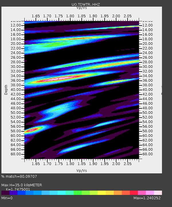
| Estimated Moho Depth: |
35.0 km |
| Estimated Crust Vp/Vs: |
1.75 |
| Assumed Crust Vp: |
6.566 km/s |
| Estimated Crust Vs: |
3.757 km/s |
| Estimated Crust Poisson's Ratio: |
0.26 |
|
| Radial Match: |
80.09707 % |
| Radial Bump: |
400 |
| Transverse Match: |
74.93703 % |
| Transverse Bump: |
400 |
| SOD ConfigId: |
28764291 |
| Insert Time: |
2022-08-28 14:07:09.436 +0000 |
| GWidth: |
2.5 |
| Max Bumps: |
400 |
| Tol: |
0.001 |
|

Signal To Noise
| Channel | StoN | STA | LTA |
| UO:TDWTR: :HHZ:20220814T13:56:52.900024Z | 7.4848495 | 1.0008556E-6 | 1.3371753E-7 |
| UO:TDWTR: :HHN:20220814T13:56:52.900024Z | 1.4057983 | 2.4813048E-7 | 1.7650503E-7 |
| UO:TDWTR: :HHE:20220814T13:56:52.900024Z | 1.1830895 | 2.2860723E-7 | 1.9322901E-7 |
| Arrivals |
| Ps | 4.1 SECOND |
| PpPs | 14 SECOND |
| PsPs/PpSs | 18 SECOND |


