You are here: Home > Network List > UW - Pacific Northwest Regional Seismic Network Stations List
> Station EPH2 Ephrata, WA, USA > Earthquake Result Viewer
EPH2 Ephrata, WA, USA - Earthquake Result Viewer
| Earthquake location: |
South Of Kermadec Islands |
| Earthquake latitude/longitude: |
-32.9/-178.0 |
| Earthquake time(UTC): |
2022/08/14 (226) 13:44:22 GMT |
| Earthquake Depth: |
33 km |
| Earthquake Magnitude: |
6.8 Mi |
| Earthquake Catalog/Contributor: |
NEIC PDE/at |
|
| Network: |
UW Pacific Northwest Regional Seismic Network |
| Station: |
EPH2 Ephrata, WA, USA |
| Lat/Lon: |
47.37 N/119.61 W |
| Elevation: |
690 m |
|
| Distance: |
95.6 deg |
| Az: |
35.562 deg |
| Baz: |
226.04 deg |
| Ray Param: |
0.0407475 |
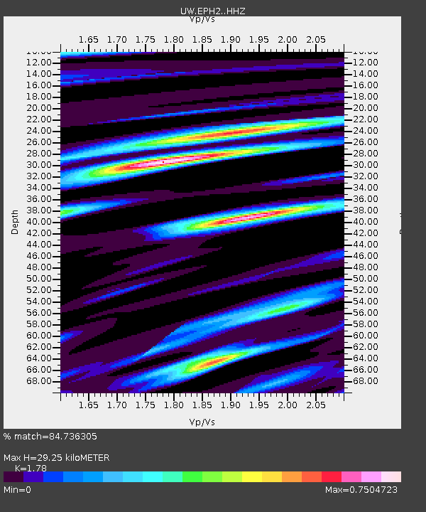
| Estimated Moho Depth: |
29.25 km |
| Estimated Crust Vp/Vs: |
1.78 |
| Assumed Crust Vp: |
6.419 km/s |
| Estimated Crust Vs: |
3.606 km/s |
| Estimated Crust Poisson's Ratio: |
0.27 |
|
| Radial Match: |
84.736305 % |
| Radial Bump: |
400 |
| Transverse Match: |
63.42898 % |
| Transverse Bump: |
400 |
| SOD ConfigId: |
28764291 |
| Insert Time: |
2022-08-28 14:08:38.567 +0000 |
| GWidth: |
2.5 |
| Max Bumps: |
400 |
| Tol: |
0.001 |
|

Signal To Noise
| Channel | StoN | STA | LTA |
| UW:EPH2: :HHZ:20220814T13:57:12.340027Z | 11.501483 | 5.9002684E-7 | 5.1300066E-8 |
| UW:EPH2: :HHN:20220814T13:57:12.340027Z | 2.4143121 | 1.30605E-7 | 5.4096155E-8 |
| UW:EPH2: :HHE:20220814T13:57:12.340027Z | 3.3906758 | 1.4819621E-7 | 4.370698E-8 |
| Arrivals |
| Ps | 3.6 SECOND |
| PpPs | 12 SECOND |
| PsPs/PpSs | 16 SECOND |


