You are here: Home > Network List > UW - Pacific Northwest Regional Seismic Network Stations List
> Station YACT Yacolt, WA, USA > Earthquake Result Viewer
YACT Yacolt, WA, USA - Earthquake Result Viewer

| Earthquake location: |
South Of Kermadec Islands |
| Earthquake latitude/longitude: |
-32.9/-178.0 |
| Earthquake time(UTC): |
2022/08/14 (226) 13:44:22 GMT |
| Earthquake Depth: |
33 km |
| Earthquake Magnitude: |
6.8 Mi |
| Earthquake Catalog/Contributor: |
NEIC PDE/at |
|
| Network: |
UW Pacific Northwest Regional Seismic Network |
| Station: |
YACT Yacolt, WA, USA |
| Lat/Lon: |
45.93 N/122.42 W |
| Elevation: |
214 m |
|
| Distance: |
93.2 deg |
| Az: |
35.212 deg |
| Baz: |
224.031 deg |
| Ray Param: |
0.041311573 |
| Estimated Moho Depth: |
63.0 km |
| Estimated Crust Vp/Vs: |
1.83 |
| Assumed Crust Vp: |
6.566 km/s |
| Estimated Crust Vs: |
3.593 km/s |
| Estimated Crust Poisson's Ratio: |
0.29 |
|
| Radial Match: |
89.634865 % |
| Radial Bump: |
400 |
| Transverse Match: |
77.3916 % |
| Transverse Bump: |
400 |
| SOD ConfigId: |
28764291 |
| Insert Time: |
2022-08-28 14:10:28.151 +0000 |
| GWidth: |
2.5 |
| Max Bumps: |
400 |
| Tol: |
0.001 |
|
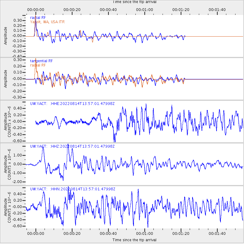
Signal To Noise
| Channel | StoN | STA | LTA |
| UW:YACT: :HHZ:20220814T13:57:01.47998Z | 16.27747 | 8.2601E-7 | 5.074561E-8 |
| UW:YACT: :HHN:20220814T13:57:01.47998Z | 3.4068289 | 2.0856636E-7 | 6.122009E-8 |
| UW:YACT: :HHE:20220814T13:57:01.47998Z | 1.9900688 | 1.2382932E-7 | 6.222364E-8 |
| Arrivals |
| Ps | 8.1 SECOND |
| PpPs | 27 SECOND |
| PsPs/PpSs | 35 SECOND |


