You are here: Home > Network List > AK - Alaska Regional Network Stations List
> Station CHN Chernabura Island, AK, USA > Earthquake Result Viewer
CHN Chernabura Island, AK, USA - Earthquake Result Viewer
| Earthquake location: |
South Of Kermadec Islands |
| Earthquake latitude/longitude: |
-32.7/-179.0 |
| Earthquake time(UTC): |
2022/08/14 (226) 13:44:17 GMT |
| Earthquake Depth: |
10 km |
| Earthquake Magnitude: |
6.4 Mww |
| Earthquake Catalog/Contributor: |
NEIC PDE/us |
|
| Network: |
AK Alaska Regional Network |
| Station: |
CHN Chernabura Island, AK, USA |
| Lat/Lon: |
54.83 N/159.59 W |
| Elevation: |
71 m |
|
| Distance: |
88.8 deg |
| Az: |
11.066 deg |
| Baz: |
196.244 deg |
| Ray Param: |
0.04235424 |
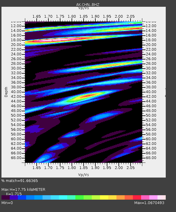
| Estimated Moho Depth: |
17.75 km |
| Estimated Crust Vp/Vs: |
1.72 |
| Assumed Crust Vp: |
5.989 km/s |
| Estimated Crust Vs: |
3.492 km/s |
| Estimated Crust Poisson's Ratio: |
0.24 |
|
| Radial Match: |
91.66365 % |
| Radial Bump: |
400 |
| Transverse Match: |
88.85036 % |
| Transverse Bump: |
400 |
| SOD ConfigId: |
28764291 |
| Insert Time: |
2022-08-28 14:12:58.926 +0000 |
| GWidth: |
2.5 |
| Max Bumps: |
400 |
| Tol: |
0.001 |
|

Signal To Noise
| Channel | StoN | STA | LTA |
| AK:CHN: :BHZ:20220814T13:56:39.368017Z | 24.780449 | 2.3698585E-6 | 9.5634206E-8 |
| AK:CHN: :BHN:20220814T13:56:39.368017Z | 6.5020742 | 5.52985E-7 | 8.5047475E-8 |
| AK:CHN: :BHE:20220814T13:56:39.368017Z | 2.3692608 | 2.450046E-7 | 1.03409725E-7 |
| Arrivals |
| Ps | 2.2 SECOND |
| PpPs | 7.9 SECOND |
| PsPs/PpSs | 10 SECOND |


