You are here: Home > Network List > XI00 - Ethiopia/Kenya Broadband Seismic Experiment Stations List
> Station JIMA Jimma > Earthquake Result Viewer
JIMA Jimma - Earthquake Result Viewer
| Earthquake location: |
Minahassa Peninsula, Sulawesi |
| Earthquake latitude/longitude: |
0.5/121.9 |
| Earthquake time(UTC): |
2001/03/14 (073) 18:56:18 GMT |
| Earthquake Depth: |
109 km |
| Earthquake Magnitude: |
5.9 MB, 6.0 MW, 5.9 MW |
| Earthquake Catalog/Contributor: |
WHDF/NEIC |
|
| Network: |
XI Ethiopia/Kenya Broadband Seismic Experiment |
| Station: |
JIMA Jimma |
| Lat/Lon: |
7.68 N/36.83 E |
| Elevation: |
1664 m |
|
| Distance: |
85.0 deg |
| Az: |
277.623 deg |
| Baz: |
90.212 deg |
| Ray Param: |
0.04480875 |
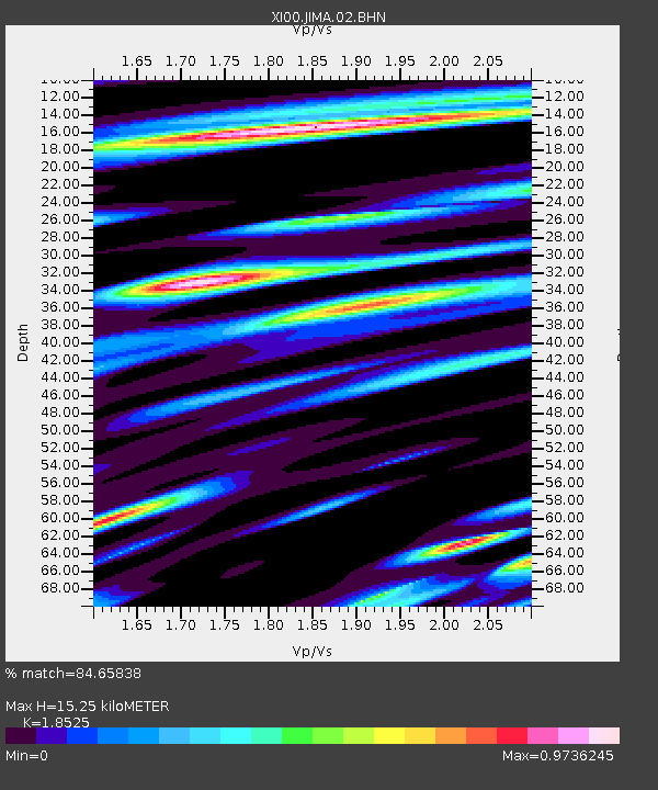
| Estimated Moho Depth: |
15.25 km |
| Estimated Crust Vp/Vs: |
1.85 |
| Assumed Crust Vp: |
6.502 km/s |
| Estimated Crust Vs: |
3.51 km/s |
| Estimated Crust Poisson's Ratio: |
0.29 |
|
| Radial Match: |
84.65838 % |
| Radial Bump: |
400 |
| Transverse Match: |
80.636925 % |
| Transverse Bump: |
400 |
| SOD ConfigId: |
3744 |
| Insert Time: |
2010-03-09 23:49:29.613 +0000 |
| GWidth: |
2.5 |
| Max Bumps: |
400 |
| Tol: |
0.001 |
|

Signal To Noise
| Channel | StoN | STA | LTA |
| XI:JIMA:02:BHN:20010314T19:08:11.205012Z | 0.9098029 | 2.0396398E-7 | 2.241848E-7 |
| XI:JIMA:02:BHE:20010314T19:08:11.205012Z | 1.4901663 | 3.1947917E-7 | 2.1439163E-7 |
| XI:JIMA:02:BHZ:20010314T19:08:11.205012Z | 1.1119746 | 1.0344837E-7 | 9.303124E-8 |
| Arrivals |
| Ps | 2.0 SECOND |
| PpPs | 6.5 SECOND |
| PsPs/PpSs | 8.6 SECOND |


