You are here: Home > Network List > CC - Cascade Chain Volcano Monitoring Stations List
> Station TCBU Trout Creek Butte at 3-Sisters, OR > Earthquake Result Viewer
TCBU Trout Creek Butte at 3-Sisters, OR - Earthquake Result Viewer
| Earthquake location: |
South Of Kermadec Islands |
| Earthquake latitude/longitude: |
-32.7/-179.0 |
| Earthquake time(UTC): |
2022/08/14 (226) 13:44:17 GMT |
| Earthquake Depth: |
10 km |
| Earthquake Magnitude: |
6.4 Mww |
| Earthquake Catalog/Contributor: |
NEIC PDE/us |
|
| Network: |
CC Cascade Chain Volcano Monitoring |
| Station: |
TCBU Trout Creek Butte at 3-Sisters, OR |
| Lat/Lon: |
44.24 N/121.66 W |
| Elevation: |
1646 m |
|
| Distance: |
92.7 deg |
| Az: |
37.261 deg |
| Baz: |
225.26 deg |
| Ray Param: |
0.041420825 |
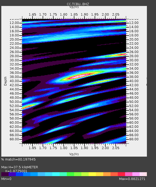
| Estimated Moho Depth: |
37.5 km |
| Estimated Crust Vp/Vs: |
1.87 |
| Assumed Crust Vp: |
6.597 km/s |
| Estimated Crust Vs: |
3.523 km/s |
| Estimated Crust Poisson's Ratio: |
0.30 |
|
| Radial Match: |
80.197945 % |
| Radial Bump: |
400 |
| Transverse Match: |
78.09727 % |
| Transverse Bump: |
400 |
| SOD ConfigId: |
28764291 |
| Insert Time: |
2022-08-28 14:21:52.471 +0000 |
| GWidth: |
2.5 |
| Max Bumps: |
400 |
| Tol: |
0.001 |
|

Signal To Noise
| Channel | StoN | STA | LTA |
| CC:TCBU: :BHZ:20220814T13:56:57.439978Z | 13.763451 | 7.4419796E-7 | 5.4070593E-8 |
| CC:TCBU: :BHN:20220814T13:56:57.439978Z | 1.9352666 | 1.9388784E-7 | 1.00186625E-7 |
| CC:TCBU: :BHE:20220814T13:56:57.439978Z | 1.7340751 | 1.8282068E-7 | 1.0542836E-7 |
| Arrivals |
| Ps | 5.1 SECOND |
| PpPs | 16 SECOND |
| PsPs/PpSs | 21 SECOND |


