You are here: Home > Network List > CI - Caltech Regional Seismic Network Stations List
> Station IRM Iron Mountain Pumping Station, Eagle Mtn., CA, USA > Earthquake Result Viewer
IRM Iron Mountain Pumping Station, Eagle Mtn., CA, USA - Earthquake Result Viewer

| Earthquake location: |
South Of Kermadec Islands |
| Earthquake latitude/longitude: |
-32.7/-179.0 |
| Earthquake time(UTC): |
2022/08/14 (226) 13:44:17 GMT |
| Earthquake Depth: |
10 km |
| Earthquake Magnitude: |
6.4 Mww |
| Earthquake Catalog/Contributor: |
NEIC PDE/us |
|
| Network: |
CI Caltech Regional Seismic Network |
| Station: |
IRM Iron Mountain Pumping Station, Eagle Mtn., CA, USA |
| Lat/Lon: |
34.16 N/115.15 W |
| Elevation: |
567 m |
|
| Distance: |
89.5 deg |
| Az: |
48.087 deg |
| Baz: |
229.175 deg |
| Ray Param: |
0.041781325 |
| Estimated Moho Depth: |
27.0 km |
| Estimated Crust Vp/Vs: |
1.75 |
| Assumed Crust Vp: |
6.276 km/s |
| Estimated Crust Vs: |
3.586 km/s |
| Estimated Crust Poisson's Ratio: |
0.26 |
|
| Radial Match: |
95.71812 % |
| Radial Bump: |
362 |
| Transverse Match: |
90.24221 % |
| Transverse Bump: |
400 |
| SOD ConfigId: |
28764291 |
| Insert Time: |
2022-08-28 14:23:09.522 +0000 |
| GWidth: |
2.5 |
| Max Bumps: |
400 |
| Tol: |
0.001 |
|
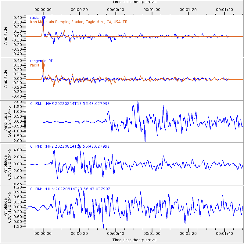
Signal To Noise
| Channel | StoN | STA | LTA |
| CI:IRM: :HHZ:20220814T13:56:43.02799Z | 3.027993 | 2.9165938E-7 | 9.632102E-8 |
| CI:IRM: :HHN:20220814T13:56:43.02799Z | 1.2858149 | 1.0580388E-7 | 8.228547E-8 |
| CI:IRM: :HHE:20220814T13:56:43.02799Z | 2.0471723 | 1.12744615E-7 | 5.507334E-8 |
| Arrivals |
| Ps | 3.3 SECOND |
| PpPs | 12 SECOND |
| PsPs/PpSs | 15 SECOND |


