You are here: Home > Network List > CI - Caltech Regional Seismic Network Stations List
> Station MPP McPhearson Peak > Earthquake Result Viewer
MPP McPhearson Peak - Earthquake Result Viewer
| Earthquake location: |
South Of Kermadec Islands |
| Earthquake latitude/longitude: |
-32.7/-179.0 |
| Earthquake time(UTC): |
2022/08/14 (226) 13:44:17 GMT |
| Earthquake Depth: |
10 km |
| Earthquake Magnitude: |
6.4 Mww |
| Earthquake Catalog/Contributor: |
NEIC PDE/us |
|
| Network: |
CI Caltech Regional Seismic Network |
| Station: |
MPP McPhearson Peak |
| Lat/Lon: |
34.89 N/119.81 W |
| Elevation: |
1739 m |
|
| Distance: |
87.2 deg |
| Az: |
44.958 deg |
| Baz: |
226.45 deg |
| Ray Param: |
0.04352064 |
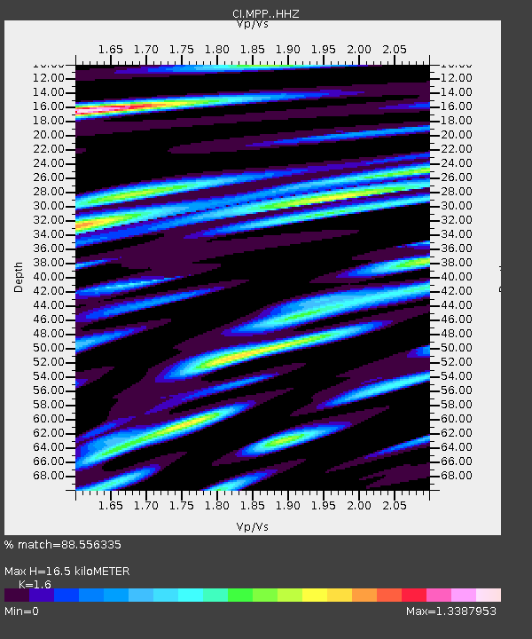
| Estimated Moho Depth: |
16.5 km |
| Estimated Crust Vp/Vs: |
1.60 |
| Assumed Crust Vp: |
6.1 km/s |
| Estimated Crust Vs: |
3.812 km/s |
| Estimated Crust Poisson's Ratio: |
0.18 |
|
| Radial Match: |
88.556335 % |
| Radial Bump: |
400 |
| Transverse Match: |
82.17703 % |
| Transverse Bump: |
400 |
| SOD ConfigId: |
28764291 |
| Insert Time: |
2022-08-28 14:23:25.227 +0000 |
| GWidth: |
2.5 |
| Max Bumps: |
400 |
| Tol: |
0.001 |
|
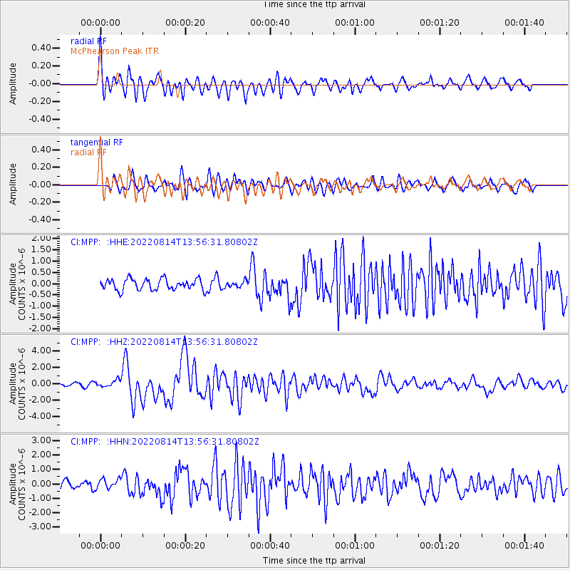
Signal To Noise
| Channel | StoN | STA | LTA |
| CI:MPP: :HHZ:20220814T13:56:31.80802Z | 3.0066772 | 4.199466E-7 | 1.3967133E-7 |
| CI:MPP: :HHN:20220814T13:56:31.80802Z | 1.0668044 | 3.561098E-7 | 3.3380982E-7 |
| CI:MPP: :HHE:20220814T13:56:31.80802Z | 0.55005 | 1.3353888E-7 | 2.4277588E-7 |
| Arrivals |
| Ps | 1.7 SECOND |
| PpPs | 6.9 SECOND |
| PsPs/PpSs | 8.5 SECOND |


