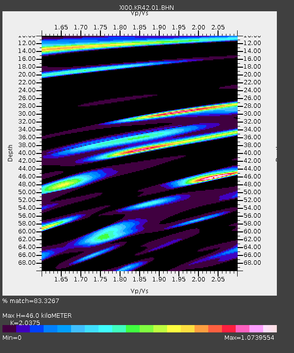
KR42 XI.KR42 - Earthquake Result Viewer

Earthquake location: Northern Molucca Sea
Earthquake latitude/longitude: 0.8/126.0
Earthquake time(UTC): 2001/10/13 (286) 16:27:00 GMT
Earthquake Depth: 33 km
Earthquake Magnitude: 5.6 MB, 5.7 MS, 6.0 MW, 5.8 MW
Earthquake Catalog/Contributor: WHDF/NEIC
Network: XI Ethiopia/Kenya Broadband Seismic Experiment
Station: KR42 XI.KR42
Lat/Lon: 0.04 N/35.73 E
Elevation: 2157 m
Distance: 90.3 deg
Az: 270.041 deg
Baz: 89.166 deg
Ray Param: 0.041682586
Estimated Moho Depth: 46.0 km
Estimated Crust Vp/Vs: 2.04
Assumed Crust Vp: 6.419 km/s
Estimated Crust Vs: 3.151 km/s
Estimated Crust Poisson's Ratio: 0.34
Radial Match: 83.3267 %
Radial Bump: 400
Transverse Match: 82.739494 %
Transverse Bump: 400
SOD ConfigId: 16820
Insert Time: 2010-03-09 23:50:10.283 +0000
GWidth: 2.5
Max Bumps: 400
Tol: 0.001

Signal To Noise

ChannelStoNSTALTA
XI:KR42:01:BHN:20011013T16:39:26.109001Z1.05657434.4850918E-74.2449375E-7
XI:KR42:01:BHE:20011013T16:39:26.109001Z1.10108974.6985133E-74.2671485E-7
XI:KR42:01:BHZ:20011013T16:39:26.109001Z2.2466279.371656E-74.171434E-7
Arrivals
Ps7.6 SECOND
PpPs21 SECOND
PsPs/PpSs29 SECOND