You are here: Home > Network List > IU - Global Seismograph Network (GSN - IRIS/USGS) Stations List
> Station JOHN Johnston Island, USA > Earthquake Result Viewer
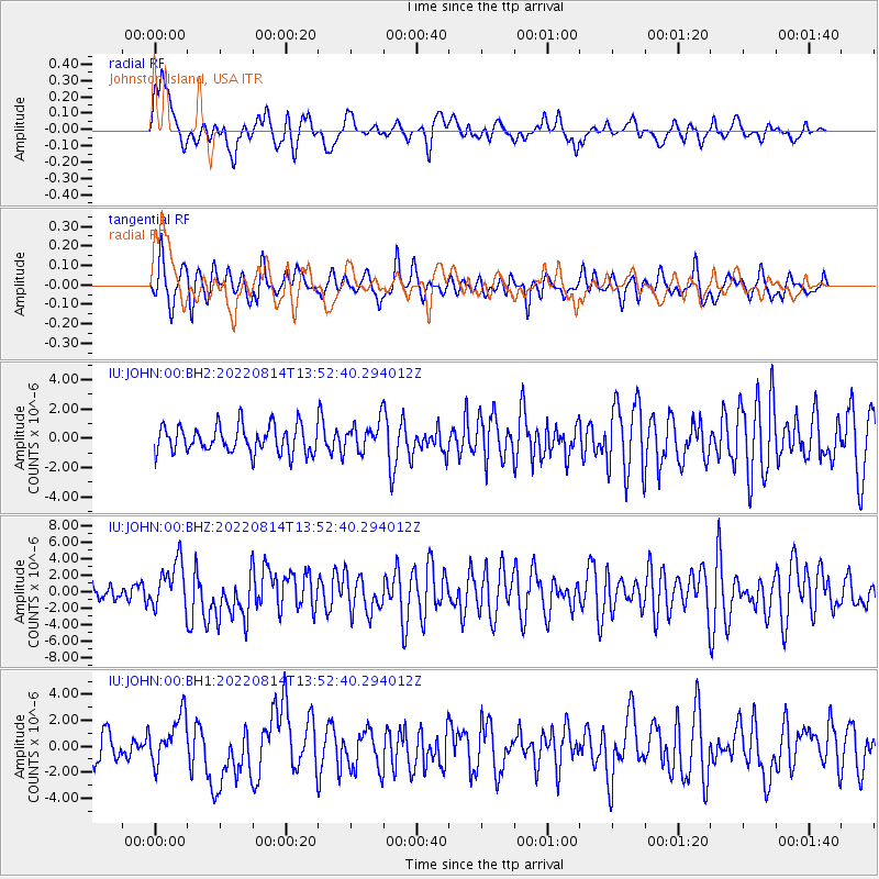
JOHN Johnston Island, USA - Earthquake Result Viewer
*The percent match for this event was below the threshold and hence no stack was calculated.
| Earthquake location: |
South Of Kermadec Islands |
| Earthquake latitude/longitude: |
-32.7/-179.0 |
| Earthquake time(UTC): |
2022/08/14 (226) 13:44:17 GMT |
| Earthquake Depth: |
10 km |
| Earthquake Magnitude: |
6.4 Mww |
| Earthquake Catalog/Contributor: |
NEIC PDE/us |
|
| Network: |
IU Global Seismograph Network (GSN - IRIS/USGS) |
| Station: |
JOHN Johnston Island, USA |
| Lat/Lon: |
16.73 N/169.53 W |
| Elevation: |
2.0 m |
|
| Distance: |
50.0 deg |
| Az: |
11.832 deg |
| Baz: |
190.395 deg |
| Ray Param: |
$rayparam |
*The percent match for this event was below the threshold and hence was not used in the summary stack. |
|
| Radial Match: |
56.46404 % |
| Radial Bump: |
400 |
| Transverse Match: |
60.997047 % |
| Transverse Bump: |
400 |
| SOD ConfigId: |
28764291 |
| Insert Time: |
2022-08-28 14:27:21.766 +0000 |
| GWidth: |
2.5 |
| Max Bumps: |
400 |
| Tol: |
0.001 |
|
Signal To Noise
| Channel | StoN | STA | LTA |
| IU:JOHN:00:BHZ:20220814T13:52:40.294012Z | 2.7526183 | 2.8398717E-6 | 1.0316984E-6 |
| IU:JOHN:00:BH1:20220814T13:52:40.294012Z | 1.5672829 | 1.8728826E-6 | 1.194987E-6 |
| IU:JOHN:00:BH2:20220814T13:52:40.294012Z | 1.0583692 | 9.792116E-7 | 9.252079E-7 |
| Arrivals |
| Ps | |
| PpPs | |
| PsPs/PpSs | |


