You are here: Home > Network List > NN - Western Great Basin/Eastern Sierra Nevada Stations List
> Station RYN Ryan, Nevada w84,gps > Earthquake Result Viewer
RYN Ryan, Nevada w84,gps - Earthquake Result Viewer
| Earthquake location: |
South Of Kermadec Islands |
| Earthquake latitude/longitude: |
-32.7/-179.0 |
| Earthquake time(UTC): |
2022/08/14 (226) 13:44:17 GMT |
| Earthquake Depth: |
10 km |
| Earthquake Magnitude: |
6.4 Mww |
| Earthquake Catalog/Contributor: |
NEIC PDE/us |
|
| Network: |
NN Western Great Basin/Eastern Sierra Nevada |
| Station: |
RYN Ryan, Nevada w84,gps |
| Lat/Lon: |
38.63 N/118.52 W |
| Elevation: |
1651 m |
|
| Distance: |
90.5 deg |
| Az: |
42.946 deg |
| Baz: |
227.178 deg |
| Ray Param: |
0.04170118 |
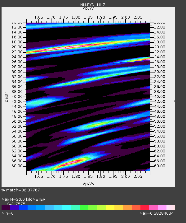
| Estimated Moho Depth: |
20.0 km |
| Estimated Crust Vp/Vs: |
1.76 |
| Assumed Crust Vp: |
6.279 km/s |
| Estimated Crust Vs: |
3.572 km/s |
| Estimated Crust Poisson's Ratio: |
0.26 |
|
| Radial Match: |
86.87767 % |
| Radial Bump: |
331 |
| Transverse Match: |
74.71425 % |
| Transverse Bump: |
400 |
| SOD ConfigId: |
28764291 |
| Insert Time: |
2022-08-28 14:29:05.679 +0000 |
| GWidth: |
2.5 |
| Max Bumps: |
400 |
| Tol: |
0.001 |
|

Signal To Noise
| Channel | StoN | STA | LTA |
| NN:RYN: :HHZ:20220814T13:56:47.38999Z | 7.5861273 | 5.108318E-7 | 6.733762E-8 |
| NN:RYN: :HHN:20220814T13:56:47.38999Z | 1.6240402 | 1.0812298E-7 | 6.657654E-8 |
| NN:RYN: :HHE:20220814T13:56:47.38999Z | 2.217972 | 1.15531556E-7 | 5.2088826E-8 |
| Arrivals |
| Ps | 2.5 SECOND |
| PpPs | 8.6 SECOND |
| PsPs/PpSs | 11 SECOND |


