You are here: Home > Network List > TX - Texas Seismological Network Stations List
> Station MB02 Rankin > Earthquake Result Viewer
MB02 Rankin - Earthquake Result Viewer
| Earthquake location: |
South Of Kermadec Islands |
| Earthquake latitude/longitude: |
-32.7/-179.0 |
| Earthquake time(UTC): |
2022/08/14 (226) 13:44:17 GMT |
| Earthquake Depth: |
10 km |
| Earthquake Magnitude: |
6.4 Mww |
| Earthquake Catalog/Contributor: |
NEIC PDE/us |
|
| Network: |
TX Texas Seismological Network |
| Station: |
MB02 Rankin |
| Lat/Lon: |
31.20 N/102.04 W |
| Elevation: |
768 m |
|
| Distance: |
96.5 deg |
| Az: |
57.153 deg |
| Baz: |
235.762 deg |
| Ray Param: |
0.04049223 |
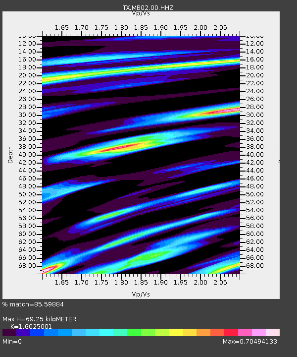
| Estimated Moho Depth: |
69.25 km |
| Estimated Crust Vp/Vs: |
1.60 |
| Assumed Crust Vp: |
6.121 km/s |
| Estimated Crust Vs: |
3.819 km/s |
| Estimated Crust Poisson's Ratio: |
0.18 |
|
| Radial Match: |
85.59884 % |
| Radial Bump: |
400 |
| Transverse Match: |
70.31724 % |
| Transverse Bump: |
400 |
| SOD ConfigId: |
28764291 |
| Insert Time: |
2022-08-28 14:31:53.997 +0000 |
| GWidth: |
2.5 |
| Max Bumps: |
400 |
| Tol: |
0.001 |
|

Signal To Noise
| Channel | StoN | STA | LTA |
| TX:MB02:00:HHZ:20220814T13:57:15.030004Z | 5.888899 | 1.910364E-7 | 3.2440088E-8 |
| TX:MB02:00:HH1:20220814T13:57:15.030004Z | 1.2245972 | 3.3508652E-8 | 2.7362999E-8 |
| TX:MB02:00:HH2:20220814T13:57:15.030004Z | 2.3692217 | 5.9563753E-8 | 2.5140643E-8 |
| Arrivals |
| Ps | 7.0 SECOND |
| PpPs | 29 SECOND |
| PsPs/PpSs | 36 SECOND |


