You are here: Home > Network List > US - United States National Seismic Network Stations List
> Station HAWA Hanford, Washington, USA > Earthquake Result Viewer
HAWA Hanford, Washington, USA - Earthquake Result Viewer

| Earthquake location: |
South Of Kermadec Islands |
| Earthquake latitude/longitude: |
-32.7/-179.0 |
| Earthquake time(UTC): |
2022/08/14 (226) 13:44:17 GMT |
| Earthquake Depth: |
10 km |
| Earthquake Magnitude: |
6.4 Mww |
| Earthquake Catalog/Contributor: |
NEIC PDE/us |
|
| Network: |
US United States National Seismic Network |
| Station: |
HAWA Hanford, Washington, USA |
| Lat/Lon: |
46.39 N/119.53 W |
| Elevation: |
364 m |
|
| Distance: |
95.2 deg |
| Az: |
36.756 deg |
| Baz: |
226.805 deg |
| Ray Param: |
0.04084806 |
| Estimated Moho Depth: |
51.75 km |
| Estimated Crust Vp/Vs: |
1.60 |
| Assumed Crust Vp: |
6.419 km/s |
| Estimated Crust Vs: |
4.012 km/s |
| Estimated Crust Poisson's Ratio: |
0.18 |
|
| Radial Match: |
94.36914 % |
| Radial Bump: |
400 |
| Transverse Match: |
81.9508 % |
| Transverse Bump: |
400 |
| SOD ConfigId: |
28764291 |
| Insert Time: |
2022-08-28 14:34:03.386 +0000 |
| GWidth: |
2.5 |
| Max Bumps: |
400 |
| Tol: |
0.001 |
|
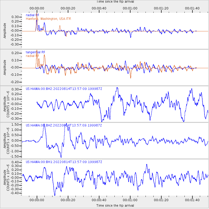
Signal To Noise
| Channel | StoN | STA | LTA |
| US:HAWA:00:BHZ:20220814T13:57:09.199987Z | 11.001843 | 6.10089E-7 | 5.5453345E-8 |
| US:HAWA:00:BH1:20220814T13:57:09.199987Z | 2.859772 | 9.927695E-8 | 3.4714986E-8 |
| US:HAWA:00:BH2:20220814T13:57:09.199987Z | 1.8385123 | 9.862955E-8 | 5.3646392E-8 |
| Arrivals |
| Ps | 4.9 SECOND |
| PpPs | 21 SECOND |
| PsPs/PpSs | 25 SECOND |


