You are here: Home > Network List > UU - University of Utah Regional Network Stations List
> Station FSB3 FORGE surface borehole 3, UT, USA > Earthquake Result Viewer
FSB3 FORGE surface borehole 3, UT, USA - Earthquake Result Viewer
| Earthquake location: |
South Of Kermadec Islands |
| Earthquake latitude/longitude: |
-32.7/-179.0 |
| Earthquake time(UTC): |
2022/08/14 (226) 13:44:17 GMT |
| Earthquake Depth: |
10 km |
| Earthquake Magnitude: |
6.4 Mww |
| Earthquake Catalog/Contributor: |
NEIC PDE/us |
|
| Network: |
UU University of Utah Regional Network |
| Station: |
FSB3 FORGE surface borehole 3, UT, USA |
| Lat/Lon: |
38.51 N/112.88 W |
| Elevation: |
1701 m |
|
| Distance: |
93.7 deg |
| Az: |
45.942 deg |
| Baz: |
230.573 deg |
| Ray Param: |
0.041204568 |
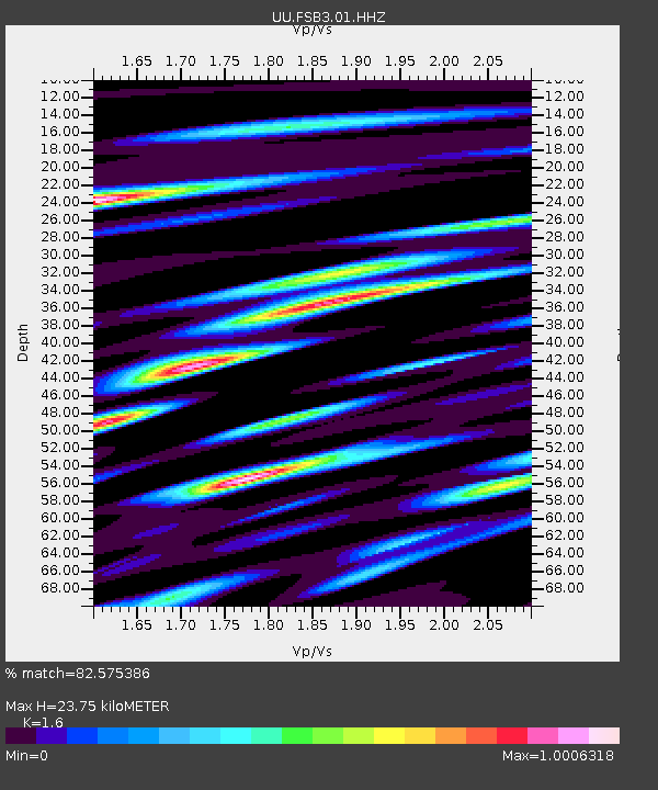
| Estimated Moho Depth: |
23.75 km |
| Estimated Crust Vp/Vs: |
1.60 |
| Assumed Crust Vp: |
6.276 km/s |
| Estimated Crust Vs: |
3.922 km/s |
| Estimated Crust Poisson's Ratio: |
0.18 |
|
| Radial Match: |
82.575386 % |
| Radial Bump: |
400 |
| Transverse Match: |
74.3095 % |
| Transverse Bump: |
400 |
| SOD ConfigId: |
28764291 |
| Insert Time: |
2022-08-28 14:34:33.567 +0000 |
| GWidth: |
2.5 |
| Max Bumps: |
400 |
| Tol: |
0.001 |
|

Signal To Noise
| Channel | StoN | STA | LTA |
| UU:FSB3:01:HHZ:20220814T13:57:02.384985Z | 3.1838336 | 1.7256738E-7 | 5.420113E-8 |
| UU:FSB3:01:HH1:20220814T13:57:02.384985Z | 1.4511132 | 5.3442253E-8 | 3.6828453E-8 |
| UU:FSB3:01:HH2:20220814T13:57:02.384985Z | 0.74788827 | 4.653012E-8 | 6.2215335E-8 |
| Arrivals |
| Ps | 2.3 SECOND |
| PpPs | 9.6 SECOND |
| PsPs/PpSs | 12 SECOND |


