You are here: Home > Network List > UW - Pacific Northwest Regional Seismic Network Stations List
> Station DAVN Davenport, WA, USA > Earthquake Result Viewer
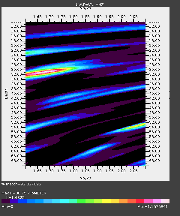
DAVN Davenport, WA, USA - Earthquake Result Viewer
| Earthquake location: |
South Of Kermadec Islands |
| Earthquake latitude/longitude: |
-32.7/-179.0 |
| Earthquake time(UTC): |
2022/08/14 (226) 13:44:17 GMT |
| Earthquake Depth: |
10 km |
| Earthquake Magnitude: |
6.4 Mww |
| Earthquake Catalog/Contributor: |
NEIC PDE/us |
|
| Network: |
UW Pacific Northwest Regional Seismic Network |
| Station: |
DAVN Davenport, WA, USA |
| Lat/Lon: |
47.80 N/118.27 W |
| Elevation: |
483 m |
|
| Distance: |
96.8 deg |
| Az: |
36.302 deg |
| Baz: |
227.772 deg |
| Ray Param: |
0.04040594 |
| Estimated Moho Depth: |
30.75 km |
| Estimated Crust Vp/Vs: |
1.68 |
| Assumed Crust Vp: |
6.419 km/s |
| Estimated Crust Vs: |
3.815 km/s |
| Estimated Crust Poisson's Ratio: |
0.23 |
|
| Radial Match: |
92.327095 % |
| Radial Bump: |
400 |
| Transverse Match: |
98.821144 % |
| Transverse Bump: |
119 |
| SOD ConfigId: |
28764291 |
| Insert Time: |
2022-08-28 14:35:16.428 +0000 |
| GWidth: |
2.5 |
| Max Bumps: |
400 |
| Tol: |
0.001 |
|

Signal To Noise
| Channel | StoN | STA | LTA |
| UW:DAVN: :HHZ:20220814T13:57:16.350012Z | 7.4439025 | 3.5222394E-7 | 4.7317105E-8 |
| UW:DAVN: :HHN:20220814T13:57:16.350012Z | 6.318745 | 2.700044E-7 | 4.2730697E-8 |
| UW:DAVN: :HHE:20220814T13:57:16.350012Z | 1.2025559 | 5.8629073E-8 | 4.875372E-8 |
| Arrivals |
| Ps | 3.3 SECOND |
| PpPs | 13 SECOND |
| PsPs/PpSs | 16 SECOND |


