You are here: Home > Network List > UW - Pacific Northwest Regional Seismic Network Stations List
> Station IRON Crane, OR, USA > Earthquake Result Viewer
IRON Crane, OR, USA - Earthquake Result Viewer
| Earthquake location: |
South Of Kermadec Islands |
| Earthquake latitude/longitude: |
-32.7/-179.0 |
| Earthquake time(UTC): |
2022/08/14 (226) 13:44:17 GMT |
| Earthquake Depth: |
10 km |
| Earthquake Magnitude: |
6.4 Mww |
| Earthquake Catalog/Contributor: |
NEIC PDE/us |
|
| Network: |
UW Pacific Northwest Regional Seismic Network |
| Station: |
IRON Crane, OR, USA |
| Lat/Lon: |
43.36 N/118.47 W |
| Elevation: |
1226 m |
|
| Distance: |
93.7 deg |
| Az: |
39.498 deg |
| Baz: |
227.336 deg |
| Ray Param: |
0.04120924 |
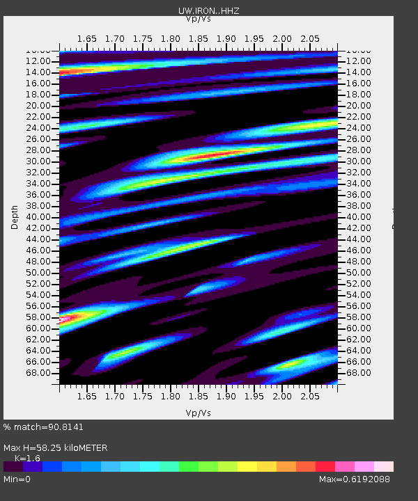
| Estimated Moho Depth: |
58.25 km |
| Estimated Crust Vp/Vs: |
1.60 |
| Assumed Crust Vp: |
6.279 km/s |
| Estimated Crust Vs: |
3.924 km/s |
| Estimated Crust Poisson's Ratio: |
0.18 |
|
| Radial Match: |
90.8141 % |
| Radial Bump: |
400 |
| Transverse Match: |
73.47631 % |
| Transverse Bump: |
400 |
| SOD ConfigId: |
28764291 |
| Insert Time: |
2022-08-28 14:35:46.651 +0000 |
| GWidth: |
2.5 |
| Max Bumps: |
400 |
| Tol: |
0.001 |
|
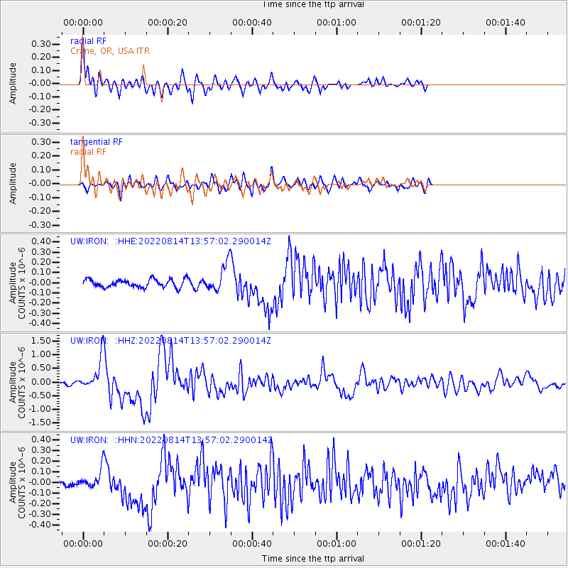
Signal To Noise
| Channel | StoN | STA | LTA |
| UW:IRON: :HHZ:20220814T13:57:02.290014Z | 9.890269 | 5.849494E-7 | 5.9143932E-8 |
| UW:IRON: :HHN:20220814T13:57:02.290014Z | 1.948344 | 8.5437954E-8 | 4.3851575E-8 |
| UW:IRON: :HHE:20220814T13:57:02.290014Z | 3.6273808 | 1.3956131E-7 | 3.84744E-8 |
| Arrivals |
| Ps | 5.7 SECOND |
| PpPs | 24 SECOND |
| PsPs/PpSs | 29 SECOND |


