You are here: Home > Network List > UW - Pacific Northwest Regional Seismic Network Stations List
> Station TWISP Winthrop, WA, USA > Earthquake Result Viewer
TWISP Winthrop, WA, USA - Earthquake Result Viewer
| Earthquake location: |
South Of Kermadec Islands |
| Earthquake latitude/longitude: |
-32.7/-179.0 |
| Earthquake time(UTC): |
2022/08/14 (226) 13:44:17 GMT |
| Earthquake Depth: |
10 km |
| Earthquake Magnitude: |
6.4 Mww |
| Earthquake Catalog/Contributor: |
NEIC PDE/us |
|
| Network: |
UW Pacific Northwest Regional Seismic Network |
| Station: |
TWISP Winthrop, WA, USA |
| Lat/Lon: |
48.46 N/120.12 W |
| Elevation: |
756 m |
|
| Distance: |
96.4 deg |
| Az: |
34.967 deg |
| Baz: |
226.555 deg |
| Ray Param: |
0.040538948 |
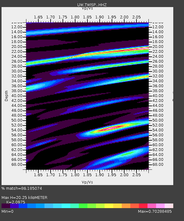
| Estimated Moho Depth: |
20.25 km |
| Estimated Crust Vp/Vs: |
2.10 |
| Assumed Crust Vp: |
6.566 km/s |
| Estimated Crust Vs: |
3.13 km/s |
| Estimated Crust Poisson's Ratio: |
0.35 |
|
| Radial Match: |
86.185074 % |
| Radial Bump: |
400 |
| Transverse Match: |
63.889065 % |
| Transverse Bump: |
400 |
| SOD ConfigId: |
28764291 |
| Insert Time: |
2022-08-28 14:37:00.936 +0000 |
| GWidth: |
2.5 |
| Max Bumps: |
400 |
| Tol: |
0.001 |
|

Signal To Noise
| Channel | StoN | STA | LTA |
| UW:TWISP: :HHZ:20220814T13:57:14.300024Z | 11.467312 | 5.211856E-7 | 4.5449674E-8 |
| UW:TWISP: :HHN:20220814T13:57:14.300024Z | 2.3742094 | 1.196626E-7 | 5.0401034E-8 |
| UW:TWISP: :HHE:20220814T13:57:14.300024Z | 2.5417316 | 1.0655469E-7 | 4.1922085E-8 |
| Arrivals |
| Ps | 3.4 SECOND |
| PpPs | 9.4 SECOND |
| PsPs/PpSs | 13 SECOND |


