You are here: Home > Network List > AU - Australian Seismological Centre Stations List
> Station BMEBF BMEBF > Earthquake Result Viewer
BMEBF BMEBF - Earthquake Result Viewer
| Earthquake location: |
Southeast Of Loyalty Islands |
| Earthquake latitude/longitude: |
-22.1/170.9 |
| Earthquake time(UTC): |
2022/08/14 (226) 21:04:46 GMT |
| Earthquake Depth: |
83 km |
| Earthquake Magnitude: |
6.2 mww |
| Earthquake Catalog/Contributor: |
NEIC PDE/us |
|
| Network: |
AU Australian Seismological Centre |
| Station: |
BMEBF BMEBF |
| Lat/Lon: |
17.87 S/122.31 E |
| Elevation: |
62 m |
|
| Distance: |
45.7 deg |
| Az: |
266.176 deg |
| Baz: |
103.622 deg |
| Ray Param: |
0.07083817 |
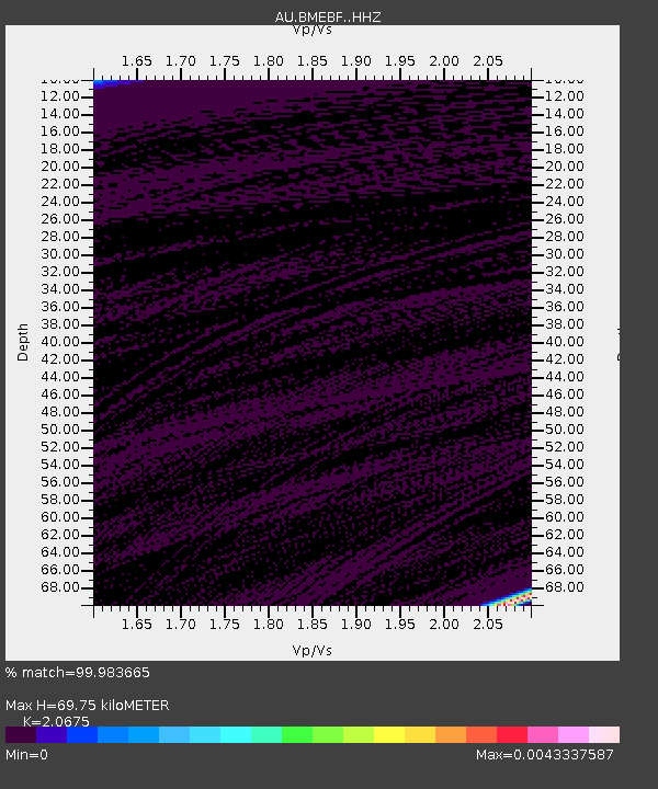
| Estimated Moho Depth: |
69.75 km |
| Estimated Crust Vp/Vs: |
2.07 |
| Assumed Crust Vp: |
6.159 km/s |
| Estimated Crust Vs: |
2.979 km/s |
| Estimated Crust Poisson's Ratio: |
0.35 |
|
| Radial Match: |
99.983665 % |
| Radial Bump: |
2 |
| Transverse Match: |
99.983665 % |
| Transverse Bump: |
2 |
| SOD ConfigId: |
28764291 |
| Insert Time: |
2022-08-28 21:11:23.007 +0000 |
| GWidth: |
2.5 |
| Max Bumps: |
400 |
| Tol: |
0.001 |
|

Signal To Noise
| Channel | StoN | STA | LTA |
| AU:BMEBF: :HHZ:20220814T21:12:29.025002Z | 6.043792 | 1.9543795E-6 | 3.2336976E-7 |
| $trig.getChannelId() | $trig.getValue() | $trig.getSTA() | $trig.getLTA() |
| AU:BMEBF: :HHE:20220814T21:12:29.025002Z | 6.1124077 | 2.8044778E-6 | 4.5881717E-7 |
| Arrivals |
| Ps | 13 SECOND |
| PpPs | 33 SECOND |
| PsPs/PpSs | 46 SECOND |


