You are here: Home > Network List > AV - Alaska Volcano Observatory Stations List
> Station KAWH Katmai, Alaska > Earthquake Result Viewer
KAWH Katmai, Alaska - Earthquake Result Viewer
| Earthquake location: |
Southeast Of Loyalty Islands |
| Earthquake latitude/longitude: |
-22.1/170.9 |
| Earthquake time(UTC): |
2022/08/14 (226) 21:04:46 GMT |
| Earthquake Depth: |
83 km |
| Earthquake Magnitude: |
6.2 mww |
| Earthquake Catalog/Contributor: |
NEIC PDE/us |
|
| Network: |
AV Alaska Volcano Observatory |
| Station: |
KAWH Katmai, Alaska |
| Lat/Lon: |
58.38 N/154.80 W |
| Elevation: |
777 m |
|
| Distance: |
85.0 deg |
| Az: |
17.323 deg |
| Baz: |
211.623 deg |
| Ray Param: |
0.044879947 |
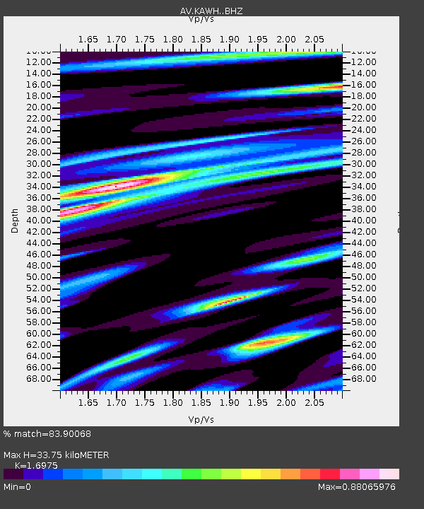
| Estimated Moho Depth: |
33.75 km |
| Estimated Crust Vp/Vs: |
1.70 |
| Assumed Crust Vp: |
6.438 km/s |
| Estimated Crust Vs: |
3.793 km/s |
| Estimated Crust Poisson's Ratio: |
0.23 |
|
| Radial Match: |
83.90068 % |
| Radial Bump: |
400 |
| Transverse Match: |
83.08695 % |
| Transverse Bump: |
400 |
| SOD ConfigId: |
28764291 |
| Insert Time: |
2022-08-28 21:12:07.661 +0000 |
| GWidth: |
2.5 |
| Max Bumps: |
400 |
| Tol: |
0.001 |
|

Signal To Noise
| Channel | StoN | STA | LTA |
| AV:KAWH: :BHZ:20220814T21:16:41.860024Z | 9.613087 | 4.3976345E-7 | 4.5746336E-8 |
| AV:KAWH: :BHN:20220814T21:16:41.860024Z | 3.2364686 | 1.2704447E-7 | 3.9254044E-8 |
| AV:KAWH: :BHE:20220814T21:16:41.860024Z | 3.624732 | 1.1825689E-7 | 3.2625003E-8 |
| Arrivals |
| Ps | 3.8 SECOND |
| PpPs | 14 SECOND |
| PsPs/PpSs | 18 SECOND |


