You are here: Home > Network List > AV - Alaska Volcano Observatory Stations List
> Station KJL Kejulik, Katmai, Alaska > Earthquake Result Viewer
KJL Kejulik, Katmai, Alaska - Earthquake Result Viewer
| Earthquake location: |
Southeast Of Loyalty Islands |
| Earthquake latitude/longitude: |
-22.1/170.9 |
| Earthquake time(UTC): |
2022/08/14 (226) 21:04:46 GMT |
| Earthquake Depth: |
83 km |
| Earthquake Magnitude: |
6.2 mww |
| Earthquake Catalog/Contributor: |
NEIC PDE/us |
|
| Network: |
AV Alaska Volcano Observatory |
| Station: |
KJL Kejulik, Katmai, Alaska |
| Lat/Lon: |
58.05 N/155.58 W |
| Elevation: |
792 m |
|
| Distance: |
84.5 deg |
| Az: |
17.144 deg |
| Baz: |
210.95 deg |
| Ray Param: |
0.045238376 |
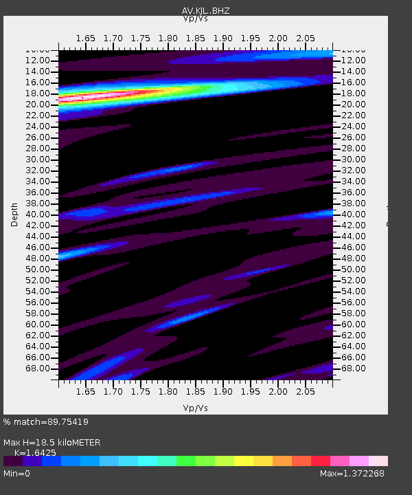
| Estimated Moho Depth: |
18.5 km |
| Estimated Crust Vp/Vs: |
1.64 |
| Assumed Crust Vp: |
6.438 km/s |
| Estimated Crust Vs: |
3.92 km/s |
| Estimated Crust Poisson's Ratio: |
0.21 |
|
| Radial Match: |
89.75419 % |
| Radial Bump: |
400 |
| Transverse Match: |
80.58645 % |
| Transverse Bump: |
400 |
| SOD ConfigId: |
28764291 |
| Insert Time: |
2022-08-28 21:12:17.747 +0000 |
| GWidth: |
2.5 |
| Max Bumps: |
400 |
| Tol: |
0.001 |
|

Signal To Noise
| Channel | StoN | STA | LTA |
| AV:KJL: :BHZ:20220814T21:16:39.379982Z | 12.850431 | 1.0007822E-6 | 7.787927E-8 |
| AV:KJL: :BHN:20220814T21:16:39.379982Z | 3.6526325 | 3.7828926E-7 | 1.035662E-7 |
| AV:KJL: :BHE:20220814T21:16:39.379982Z | 2.2974494 | 2.3055601E-7 | 1.0035304E-7 |
| Arrivals |
| Ps | 1.9 SECOND |
| PpPs | 7.4 SECOND |
| PsPs/PpSs | 9.3 SECOND |


